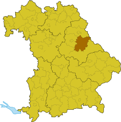
Schwandorf (district)
| Schwandorf | |
|---|---|
| District | |
 | |
| Country |
|
| State | Bavaria |
| Adm. region | Oberpfalz |
| Capital | Schwandorf |
| Area | |
| • Total | 1,472.88 km2 (568.68 sq mi) |
| Population (31 December 2015)[1] | |
| • Total | 144,864 |
| • Density | 98/km2 (250/sq mi) |
| Time zone | CET (UTC+1) |
| • Summer (DST) | CEST (UTC+2) |
| Vehicle registration | SAD |
| Website | landkreis-schwandorf.de |
Schwandorf is a Kreis (district) in the east part of Bavaria, Germany. Neighboring districts are (from the east clockwise) Cham, Regensburg, Neumarkt, Amberg-Sulzbach, Neustadt (Waldnaab), and the Czech Plzeň Region.
Geography
The main rivers of the district are the Naab and the Regen.
Climate
Climate in this area has mild differences between highs and lows, and there is adequate rainfall year round. The Köppen Climate Classification subtype for this climate is "Cfb". (Marine West Coast Climate/Oceanic climate).[2]
History
The district was created in 1972 by merging the previous districts Burglengenfeld, Oberviechtach, Nabburg, Neunburg vorm Wald, and the previously district-free city Schwandorf.
Coat of arms
| The coat of arms shows the lion of the Palatinate to the left. The tower in the right half symbolizes the many fortresses and castles in the district. The wavy line and the mill wheel in the bottom stand for the many rivers and the water mills in the district. |
Towns and municipalities
| Towns | Markt | Verwaltungsgemeinschaften | Municipalities |
|---|---|---|---|
|
|||
| ¹ administrated within a Verwaltungsgemeinschaft | |||
References
External links
| Wikimedia Commons has media related to Landkreis Schwandorf. |
- Official website (German)
- Schwandorf – pictures, sights, day trips
Coordinates: 49°20′N 12°10′E / 49.33°N 12.17°E
This article is issued from Wikipedia - version of the 5/16/2015. The text is available under the Creative Commons Attribution/Share Alike but additional terms may apply for the media files.