Karanis

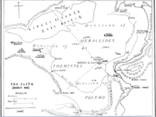
Karanis (Greek: Καρανίς), located in modern Kom Aushim, was an agricultural town in Graeco-Roman Egypt, located in the northeast corner of the Fayum.[1] "It was one of a number of towns established in the Arsinoite nome under Ptolemy II Philadelphus as part of a scheme to settle Greek mercenaries among the indigenous Egyptians and to exploit the potential fertile Fayum basin".[2]
South temple
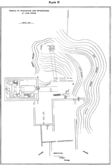
The earliest archaeological origins are at the South Temple and can be traced to the 1st century BC.[3] It is from this point that the town expanded north when Augustus, having conquered Egypt and also recognizing the Fayum’s agricultural potential, sent workers to clean up the canals and restore the dikes that had fallen into decline, restoring productivity to the area.[4] A Roman-style temple was then built on top of the foundations of the old temple at the beginning of the 1st century AD. During this period of rebuilding, a smaller, more Egyptian-style North Temple was also built. The South Temple was dedicated to the local crocodile gods, Pnepheros and Petesouchos, but there is no clear dedication in the North Temple.[5]
Conditions in the town
The Fayum towns were settled by Roman veterans after Augustus conquered Egypt, though the small number of Latin papyri found in Karanis (only two) and the overwhelming number of Greek papyri from or concerning these veterans from this period suggest that these new soldiers may not have been culturally Roman but instead Greek, or at the very least from the Eastern empire.[6] "The peace and political stability brought by Augustus and kept alive by his successors, meant prosperity for generations of landholders at Karanis well into the second century.
In the late second century, and again in the second quarter of the third, there were notable recessions that mirrored difficulties experienced by the Empire at large,[4] houses had fallen down by the end of the 3rd century,[3] and the town was completely abandoned by the early 5th century.[7] The dry conditions that Karanis was left in are most suitable for the preservation of papyri,[8] and it is for this that Karanis is most well known by archaeologists.
Papyri

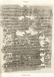
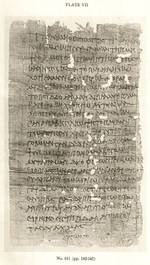
The papyri excavated are historically significant in that they come from the same place and time, all dating from the period between the reign of Diocletian and the 370s.[11] Also, with Karanis being a relatively poor town, the documents and artifacts excavated "[provide] a microcosm of life as it was lived by ordinary people in Egypt under Greek and Roman rule," and provide evidence of the whole of Egypt’s relationship to the Empire of Rome.[12] The papyri contain mostly tax records, which is how archaeologists have determined that Karanis and its veterans were mostly poor, self-sufficient farmers who did not have much contact with other towns in the region.[13]
Excavations
These excavations were extremely troubled to say the least. In the late 19th and early 20th centuries, farmers would “obtain permits to remove soil from the Karanis mound to use as fertilizer (sebbakh)”, the organic decay making the soil very rich.

 |
 | |
The first real excavation was in 1895 by Englishmen Bernard Pyne Grenfell and Arthur Surridge Hunt, though they felt the area had been too plundered to produce anything of much value. At this time, archaeology as a pursuit of knowledge was wholly unheard of, and papyri and other artifacts were treated more as items to collect. Also during this time (i.e., the late 19th and early 20th centuries), excavators were almost solely interested in artifacts dating to the older dynasties, and Graeco-Roman sites such as Karanis continued to be plundered for sebbakh until Francis W. Kelsey, a professor of Latin language and literature at the University of Michigan, observed this devastation and received grants to search for an excavation site in 1924. Starting excavations of Karanis in 1925, his goal was to "increase exact knowledge rather than the amassing of collections", with a focus on common people.[15] The papyri collected are now part of the University of Michigan Papyrus Collection. More recent excavations have been done by the Cairo University, the French Institute, and for the last few years by a combined collaboration of UCLA and the University of Groningen (RUG) in the Netherlands.[16]
Notes
- ↑ Richard Alston, Soldier and Society in Roman Egypt (London: Routledge, 1998) 118
- ↑ Elaine K. Gazda, ed. Karanis: An Egyptian Town in Roman Times (Ann Arbor: Kelsey Museum of Archaeology, University of Michigan, 1983) 8
- 1 2 Alston 119
- 1 2 Gazda 9
- ↑ Alston 120
- ↑ Alston 138
- ↑ Roger S. Bagnall and Naphtali Lewis, eds. Columbia Papyri VII (Ann Arbor: Scholars Press, 1979) 2
- ↑ Gazda 1
- ↑ Herbert Chayyim Youtie and John Garret Winter, eds. Michigan Papyri, Vol. VIII (Ann Arbor: The University of Michigan Press, 1951) 33
- ↑ Youtie 142
- ↑ Bagnall 1
- ↑ Gazda 6
- ↑ Alston 122
- ↑ Bernard P. Grenfell, et al., Fayum Town and Their Papyri (London: Offices of the Egypt exploration fund [etc.], 1900) 28-29
- ↑ Gazda 2-5
- ↑ Jimmy Dunn. "Karanis in the Fayoum of Egypt. Tour Egypt. (InterCity Oz, Inc., 2007)
Bibliography
Alston, Richard. Soldier and Society in Roman Egypt: Social History. London: Routledge, 1998.
Bagnall, Roger S., Naphtali Lewis, eds. Columbia Papyri VII: Fourth Century Documents from Karanis. Ann Arbor: Scholars Press, 1979.
Gazda, Elaine K., ed. Karanis: An Egyptian Town in Roman Times; discoveries of the University of Michigan Expedition to Egypt (1924-1925). Ann Arbor: Kelsey Museum of Archaeology, The University of Michigan, 1983.
Grenfell, Bernard P., Arthur S. Hunt, David G. Hogarth. Fayum Towns and Their Papyri. London: Office's of the Egypt exploration fund [etc.], 1990.
Youtie, Herbert Chayyim, and John Garret Winter, eds. Michigan Papyri, Vol. VIII: Papyri and Ostraca from Karanis, Second Series. Ann Arbor: The University of Michigan Press, 1951.
Coordinates: 29°31′04″N 30°54′12″E / 29.51778°N 30.90333°E
