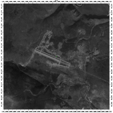
Kamenny Ruchey
| Kamenny Ruchey | |||||||||||
|---|---|---|---|---|---|---|---|---|---|---|---|
| IATA: none – ICAO: UHKG | |||||||||||
| Summary | |||||||||||
| Airport type | Military | ||||||||||
| Operator | Russian Navy | ||||||||||
| Location | Sovetskaya Gavan | ||||||||||
| Elevation AMSL | 659 ft / 201 m | ||||||||||
| Coordinates | 49°14′0″N 140°11′36″E / 49.23333°N 140.19333°ECoordinates: 49°14′0″N 140°11′36″E / 49.23333°N 140.19333°E | ||||||||||
| Runways | |||||||||||
| |||||||||||

Kamenny Ruchey (also Mongokhto, Alekseyevka, and Mongohto) (Russian: Монгохто, Каменный Ручей) (ICAO: UHKG) is an air base in Russia located 29 km north of Sovetskaya Gavan. Located just north of Vanino, this is a major military naval airfield that has 63 hardened areas. The airfield is designated by CAICA as Kamenny Ruchey, but Russian topographic maps indicate the nearby settlement northeast of the airfield is Mongokhto, which is also synonymous with the military base. The airfield was a joint Soviet Navy base with the 143 MRAD (143rd Naval Aviation Division), flying Tupolev Tu-16, Tupolev Tu-22M, and the 310 OPLAP (310th Independent Long Range Anti-Submarine Aviation Regiment) flying Tupolev Tu-142 aircraft.
The airbase was completed in 1953. During the 1970s it was one of the largest bases in the Soviet Far East, with 8000 residents in Mongokhto. The Navy nuclear weapons storage is either at this airfield or at Maygatka. In 1997 50 family members blocked the runway over back wages.
A high-res Google image from around 2000 showed 19 Tupolev Tu-22M and 14 Tupolev Tu-142 aircraft.
Near the airbase there are other two, May-gatka Airport and Mayskiy Airport airbase .
External links
- Social Portrait of settlement Mongokhto (Russian)
- Vanino Transportation Network (Russian)
- Mongokhto website (Russian) - for former residents