Kalathur
| Kalathur களத்தூர் | |
|---|---|
| Village | |
|
Arulmigu Shri Muthumariaman Thirukovil(Temple),Kalathur. | |
 Kalathur Location in Tamil Nadu, India | |
| Coordinates: 10°20′N 79°12′E / 10.33°N 79.20°ECoordinates: 10°20′N 79°12′E / 10.33°N 79.20°E | |
| Country |
|
| State | Tamil Nadu |
| Region | Chola Nadu |
| District | Thanjavur |
| Zone | Central |
| Government | |
| • Type | Village Panchayat |
| • Body | Kalathur Panchayat |
| Elevation | 34 m (112 ft) |
| Population (2011) | |
| • Total | 6,424 |
| Demonym(s) | Kalathuraan |
| Time zone | IST (UTC+5:30) |
| PIN | 614804[1] |
| Telephone code | +91 4373 |
| Vehicle registration | TN 49 |
Kalathur(களத்தூர்) is a panchayat village in Peravurani panchayat Union[2] of Thanjavur district in the Indian state of Tamil Nadu. Kalathur is a part of the Pattukkottai taluk[3] of Thanjavur district and Located 67 kilometres (42 mi) south of Thanjavur[4] connected via State Highway 29.
Kalathur comes under the Peravurani assembly[5] constituency which elects a member to the Tamil Nadu Legislative Assembly once every five years and it is a part of the Thanjavur (Lok Sabha constituency)[6] which elects its Member of Parliament (MP) once in five years.
Geography
Kalathur is located at 10°20′N 79°12′E / 10.33°N 79.20°E.[7] It has an average elevation of 34 m (112 ft).
Economy
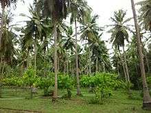
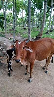
.The village is a part of the fertile Cauvery delta region,[8] and agriculture is the principal occupation of the people of Kalathur. Cultivated crops include coconut, Paddy, Cotton, Sugarcane, Bananaa, Cocoa.Coconut & paddy cultivation is practised extensively.Cattle rearing is also a major livelihood of kalathur peoples.[9]
Administration
The Kalathur Panchayat comprises Kalathur east, Kalthur west, Nadankkadu, Pookkanviduthi and Sithukkadu villages and is currently being administered by the Village president, elected once in 5 years.[10]
Demographics
As of 2011 Population Census, the village comprises 1576 families residing with a population of 6,424[11] of which 3190 are males while 3234 are females.[12] The average literacy rate of the village was 79.09%, compared to the national average of 72.99%. [13]
Transportation
The state highways SH29 and Major District road 829 pass through Kalathur.[14] There are regular buses to Pattukkottai and Peravurani.The nearest Railway station is Peravurani railway station,[15] located 8 kilometres (5.0 mi) away and the nearest airport is Tiruchirapalli International Airport.[16]
References
- ↑ Kalathur Pincode
- ↑ Kalathur - Part of Peravurani Union
- ↑ Kalathur - Part of Pattukkottai Taluk
- ↑ Kalathur - Part of Thanjavur District
- ↑ Kalathur, Part of peravurani constituency
- ↑ Kalathur, Thanjavur MP constituency
- ↑ Kalathur, Thanjavur Map
- ↑ Kalathur Cauvery delta
- ↑ Kalathur Cococnut
- ↑ Kalathur Panchayat
- ↑ Kalathur - 2011 Population
- ↑ Kalathur east polpulation
- ↑ Kalathur west population
- ↑ Kalathur road no 829
- ↑ Nearest Railway station
- ↑ Nearest Airport