Kailahun District
| Kailahun District | |
|---|---|
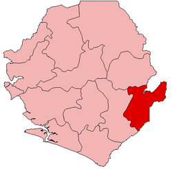
 Location of Kailahun District in Sierra Leone | |
| Coordinates: 8°10′N 10°45′W / 8.167°N 10.750°WCoordinates: 8°10′N 10°45′W / 8.167°N 10.750°W | |
| Country | Sierra Leone |
| Province | Eastern Province |
| Capital | Kailahun |
| Largest city | Kailahun |
| Government | |
| • Type | District Council |
| • Council Chairman | Alex Bhonapha (SLPP) |
| Area | |
| • Total | 3,859 km2 (1,490 sq mi) |
| Population (2015 census )[1] | |
| • Total | 525,372 |
| • Density | 140/km2 (350/sq mi) |
| Time zone | Greenwich Mean Time (UTC-5) |
Kailahun District is a district in the Eastern Province of Sierra Leone. Its capital and largest city is the town of Kailahun. The other major towns in the district include Segbwema, Koindu, Pendembu and Daru. As of the 2015 census, the district had a population of 525,372.[1] Kailahun District is subdivided into fourteen chiefdoms.
The District of Kailahun borders Liberia to the east, Guinea and the Kono District to the north, and Kenema District to the west. The border of the district with Guinea is formed by a section of the Moa River.[2] The total area of the district is 4,859 km2 (1,876 sq mi). The population of Kailahun District is largely from the Mende ethnic group. The district is predominantly muslim.
Kailahun District is the birthplace of former Sierra Leone's president Ahmad Tejan Kabbah, who was born in the town of Pendembu.
Government and politics
Kailahun District is governed with a district council form of government, which is headed by a District Council Chairman, who is chief executive officer in the District and is responsible for the general management of the district and for seeing that all local laws are enforced. The District Council Chairman is elected directly by the residents of the district of Kailahun every four years. The current chairman of Kailahun district council is Alex Bhonapha of the Sierra Leone People's Party (SLPP), who easily won the 2012 District Chairperson election with 75.73%, defeating his main opponent Augustine Kortu of the All People's Congress (APC) who took 20.31%.[3]
Kailahun District is a reliable political stronghold of the Sierra Leone People's Party (SLPP), the main opposition party in Sierra Leone. The District overwhelmingly supports the SLPP by a large majority in Presidential, Parliamentary and local councils elections. The SLPP had won every Sierra leone president elections in the District by a large majority; including the 2012 Presidential election, when the SLPP presidential candidate Julius Maada Bio won 73.3% of the vote in the District, as he easily defeated the incumbent president Ernest Bai Koroma in the District who took 22.6%.[4]
Radio
Demographics of Kailahun District
The population of Kailahun District is almost entirely from the Mende.
Economy
Kailahun has a mixed economy, made up of small-scale mining as well as agricultural production of coffee, cacao and rice. Local Government collects property taxes with the assistance of Revenue Development Foundation
Administrative divisions
Chiefdoms

The district is made up of fourteen chiefdoms as the third level of administrative subdivision.
- Dea – Baiwala
- Jaluahun – Segbwema
- Jawei – Daru
- Kissi Kama – Dea
- Kissi Teng – Kangama
- Kissi Tongi – Buedu
- Luawa – Kailahun
- Malema – Jojoima
- Mandu – Mobai
- Peje Bongre – Manowa
- Peje West – Bunumbu
- Penguia – Sandar
- Upper Bambara – Pendembu
- Yawei – Bandajuma
Major towns
- Segbwema, largest city
- Kailahun, district headquarters
- Pendembu, second largest town
- Koindu, fourth largest
- Daru
Notable people from Kailahun District
- Ahmad Tejan Kabbah, former President of Sierra Leone
- Steady Bongo, Sierra Leonean musician
- Hindowa Momoh, former President of the National Union of Sierra Leone Students
- Ibrahim Sheriff, Founder, Sherix Webradio and Philanthropist
References
- 1 2 http://archive.is/20121216142937/http://www.world-gazetteer.com/wg.php?x=&men=srcg&lng=en&des=wg&srt=npan&col=abcdefghinoq&msz=1500&geo=0
- ↑ Katrina Manson and James Knight (2009). Sierra Leone. Bradt Travel Guides., page 275.
- ↑ http://www.nec-sierraleone.org/index_files/Mayor_Chairperson%20Result%202012.pdf
- ↑ http://www.nec-sierraleone.org/index_files/STATEMENT%20%20FROM%20NEC%20CHAIRPERSON%20(press%20district).pdf