Ise-Nakagawa Station
Ise-Nakagawa Station 伊勢中川駅 | |
|---|---|
 Ise-Nakagawa Station | |
| Location |
1-93 Ureshinonakagawashin-cho, Matsusaka, Mie (三重県松阪市嬉野中川新町一丁目93) Japan |
| Operated by | Kintetsu Railway |
| Line(s) |
|
| History | |
| Opened | 1930 |
| Previous names | Sankyū-Nakagawa (until 1941) |
| Traffic | |
| Passengers (FY2010) | 3696 daily |
Ise-Nakagawa Station (伊勢中川駅 Ise-Nakagawa-eki) is a major junction railway station operated by the private railway operator Kintetsu in Matsusaka, Mie Prefecture. The station is served by the Yamada Line, and is a Terminus for the Osaka Line.[1]
The station has a stationmaster and is responsible for the administration of the sections between Higashi-Aoyama Station and this station on the Osaka Line and between this station and Higashi-Matsusaka Station on the Yamada Line.
Lines
Station layout
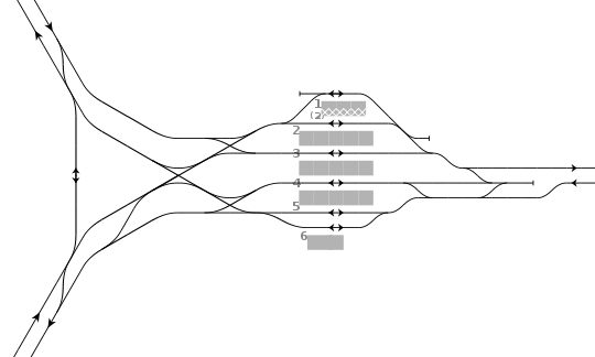
Ise-Nakagawa Station has six parallel tracks numbered 1 through 6. Four island platforms are located to serve Tracks 1 & 2, 2 & 3, 3 & 4, and 4 & 5. Track 6 is served by one side platform. This layout enables trains on Tracks 2, 3, 4 and 5 to open doors on the both sides of the trains for easy transfer among the three connecting major lines at this station.
Limited express trains running directly between the Osaka Line and the Nagoya Line do not pass through the station. Instead, these trains use a crossover between the two lines located north of the station. The two trunk lines and this crossover constitutes a triangle.
| 1 | ■ Yamada Line | local trains for Matsusaka, Ujiyamada, Toba and Kashikojima |
| ■ Nagoya Line | local trains starting for Tsu, Yokkaichi and Nagoya | |
| 2, 3 | ■ Yamada Line | for Matsusaka, Ujiyamada, Toba and Kashikojima |
| ■ Nagoya Line | starting for Tsu, Yokkaichi and Nagoya in the mornings and the evenings | |
| ■ Osaka Line | express trains starting for Osaka Uehommachi | |
| 4, 5 | ■ Nagoya Line | for Tsu, Yokkaichi and Nagoya |
| ■ Osaka Line | for Osaka Uehommachi, Osaka Namba, Kōbe, Kyōto and Nara | |
| 6 | ■ Osaka Line | local trains for Higashi-Aoyama and Nabari |
| Nagoya Line for Tsu, Yokkaichi and Nagoya | |
 | Yamada Line for Ujiyamada, Toba, and Kashikojima |
| Osaka Line for Osaka Uehommachi, Osaka Namba and Kyōto |
Adjacent stations
| « | Service | » | ||
|---|---|---|---|---|
| Osaka Line | ||||
| Kawai-Takaoka | Local | (Yamada Line) | ||
| Sakakibara-Onsenguchi | Express | (Yamada Line) | ||
| Sakakibara-Onsenguchi | Rapid Express | (Yamada Line) | ||
| Iga-Kambe Sakakibara-Onsenguchi |
Limited Express | (Yamada Line) | ||
| Kintetsu Nagoya Line | ||||
| Momozono | Local | (Yamada Line) | ||
| Hisai | Express | (Yamada Line) | ||
| Tsu Hisai |
Limited Express | (Yamada Line) | ||
| Yamada Line | ||||
| (Osaka Line) (Nagoya Line) |
Local | Ise-Nakahara | ||
| (Osaka Line) (Nagoya Line) |
Express | Matsusaka | ||
| (Osaka Line) | Rapid Express | Matsusaka | ||
| (Osaka Line) (Nagoya Line) |
Limited Express | Matsusaka | ||
Surrounding area
- Ureshino Library
- Ureshino Furusato Center
- Yuu-Store supermarket
History
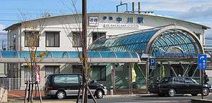
Ise-Nakagawa Station opened on May 18, 1930 as Sankyū-Nakagawa Station (参急中川駅 Sankyū-Nakagawa-eki) on the Sangu Express Electric Railway. On March 15, 1941, the Sangu Express Electric Railway merged with Osaka Electric Railway to become a station on Kansai Express Railway's Yamada Line, at which time the station was renamed it its present name.[4] This line in turn was merged with the Nankai Electric Railway on June 1, 1944, to form Kintetsu.[4] A new station building was completed in 2004.
References
- ↑ Terada, Hirokazu (July 2002). データブック日本の私鉄 [Databook: Japan's Private Railways]. Japan: Neko Publishing. ISBN 4-87366-874-3.
- ↑ Kawashima, Ryōzō (1996). Zenkoku Tetsudō Jijō Dai-kenkyū: Nagoya Toshin-bu, Mie Hen (in Japanese). Sōshisha. p. 172. ISBN 978-4-7942-0700-5.
- ↑ Kawashima, Ryōzō (1993). Zenkoku Tetsudō Jijō Dai-kenkyū: Ōsaka Toshin-bu, Nara Hen (in Japanese). Sōshisha. p. 134. ISBN 978-4-7942-0498-1.
- 1 2 Kintetsu Company History
External links
| Wikimedia Commons has media related to Ise-Nakagawa Station. |
- (Japanese) Kintetsu: Ise-Nakagawa Station
- (English) Kintetsu: Ise-Nakagawa Station layout
Coordinates: 34°38′6.08″N 136°28′40.39″E / 34.6350222°N 136.4778861°E