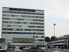
Intercity House
| Intercity House | |
|---|---|
 InterCity House in 2008 | |
| General information | |
| Status | Complete |
| Type | Office |
| Location | North Road West, Plymouth, Devon, PL4 6AB |
| Completed | 1962 |
| Owner | Network Rail |
| Height | |
| Roof | 47.20 m (154.9 ft) |
| Technical details | |
| Floor count | 10 |
Intercity House is an office building situated at Plymouth railway station (formerly known as Plymouth North Road station),[1] the main rail station in Plymouth, Devon. Opened in 1962 by Dr Beeching,[2] it was constructed by British Rail between 1956 and 1962 as part of the post war reconstruction detailed in A Plan for Plymouth,[3][4][5] put forward by Sir Patrick Abercrombie at the request of Plymouth City Councillors.
It has 10 stories and is 47.2 m high and is one of the three tallest buildings in Plymouth (2014).[6]
The building is scheduled for a major update,[7] as part of a ten-year plan to improve the facilities at the station[8]
Bibliography
- J. Paton Watson and Patrick Abercrombie, A Plan for Plymouth, Underhill, (Plymouth). Ltd., 1943.
References
- ↑ Moseley, Brian (7 May 2007). "Plymouth Station (formerly Plymouth North Road Station)". The Encyclopaedia of Plymouth History. Plymouthdata.info. Archived from the original on 16 May 2008. Retrieved 13 February 2015.
- ↑ "The history of Plymouth Railway Station in pictures". The Herald (Plymouth). 20 January 2015. Archived from the original on 13 February 2015. Retrieved 13 February 2015.
- ↑ A plan for Plymouth : the report prepared for the City Council, by James Paton Watson, L. Dudley Stamp, Sir Patrick Abercrombie, Gilbert Wooding Robertson, Plymouth City Council, Published by Underhill, Plymouth, 1943, OCLC 2659559
- ↑ "A PLAN FOR PLYMOUTH". Plymouth.gov.uk. Retrieved 23 October 2014.
- ↑ "A plan for Plymouth : the report prepared for the City Council : J. Watson (James Paton) : 1943 2nd ed.". Retrieved 23 October 2014.
- ↑ "Inter-City House". Emporis.com. Retrieved 23 October 2014.
- ↑ "Next phase of revamp of Plymouth train station begins". Plymouth Herald. Retrieved 23 October 2014.
- ↑ "Ten-year plan for redevelopment of Plymouth Rail Station is now underway, says council". Plymouth Herald. Retrieved 23 October 2014.
External links
Coordinates: 50°22′39″N 4°08′36″W / 50.3774°N 4.1433°W
This article is issued from Wikipedia - version of the 9/15/2016. The text is available under the Creative Commons Attribution/Share Alike but additional terms may apply for the media files.