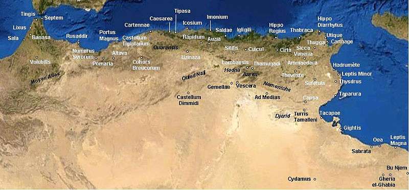
Igilgili
 Igilgivi was located between Icosium (Algiers) and Hippo Regius (Annaba) | |
 Shown within Algeria | |
| Location | Algeria |
|---|---|
| Region | Jijel Province |
| Coordinates | 36°49′00″N 5°46′00″E / 36.816667°N 5.766667°E |
Igilgili was a Roman-Berber colonia in located in present-day Jijel, Algeria.
History
Igilgili was initially a small Carthaginian trading port. After the defeat of Jugurtha by the Romans and allies in 105 BC, the Phoenician city came under the rule of the Roman Empire and turned into a Roman colony under Augustus in 33 BC. From the beginning, its residents enjoyed full Roman citizenship. Once the Romans occupied the whole of North Africa, the city of Igilgili was administratively attached to the Roman province of Mauretania Caesariensis and later to the one of Mauretania Setifensis. In those years Igilgili grew to nearly 6,000 inhabitants and was very rich, with commerce to Italy and Spain.
The site (of Igilgili) is on a low peninsula and a small coastal plain enclosed by a ring of hills, about half-way between Bône and Algiers. The Roman colony, founded by Augustus (Plin. HN 5.21), is mentioned by Ptolemy (4.2.2), in the Antonine Itinerary, the Peutinger Table, and in the Ravenna Geographer. It was a fairly important port until the Byzantine period. Six roads went out from it...The remains of town walls (which have now disappeared) belonged to the Roman period. An aqueduct comes from the S. To the SE of the knoll of St. Ferdinand were public baths. They have produced Dionysiac and ornamental mosaics, now at the Skikda Museum (formerly Philippeville), and sculptures (a satyr's head at the Algiers Museum). Other artifacts include statuettes, lamps, and votive stelae (at the Skikda Museum and the Louvre). M. Leglay [1]
Igilgili population and its surroundings became massively Christian in the fourth century, with the formalization of this religion under Emperor Constantine, although the first conversions date back to two centuries earlier. When emperor Valentinian I sent his magister militum Theodosius (father of Theodosius I) to attack Firmus, he landed in Igilgili in 374 AD; there Firmus tried to find a compromise with him, but Theodosius refused peace to Firmus, who had proclaimed himself emperor. With the support of the indigenous local African tribes, Firmus obliged Theodosius to a bloody and hopeless campaign in which Igilgili region was devastated for a couple of years. In the end, however, Firmus was betrayed by one of his supporters, and chose suicide over capture.
The Roman city remained rich until the attack and partial destruction by the Vandals in 429 AD. Subsequently, the city was taken in 533 AD by the Byzantine (Eastern Roman Empire) and their Romano-African supporters (Romanized Berber dwellers) from the Vandals. Catholicism and the Roman way of life were restored under the Byzantines, while the remaining Vandals took refuge in the surrounding mountains (of actual "Little Kabylie").[2]
At the time of arrival of the Umayyads and Islam in the region in the late seventh century, Byzantine officials with troops and some Roman Catholic and Latinized Berbers lived in the city of Igilgili. While nearby of the city the camps were populated by peasants Berber "Kutama" (called Ucutamani by the Byzantines), not fully Christians.
Around 650 AD the first riders of Islam appeared. Queen Kahina was defeated in 698 AD by the Muslim troops of Hassan Ibn Numan and the city of Igilgili was renamed "Jijel". It was incorporated into the Umayyad empire. The population of the region, which was then mainly Christian, converted gradually to Islam, and by the end of the eighth century it had already become overwhelmingly Muslim. The Arabic language there diffused slowly and gradually, replacing Latin in Jijel city only in the early eighth century.
Notes
- ↑ "Saturne Africain". Monuments, 1966 (The Princeton encyclopedia of classical sites)
- ↑ History of Igilgili/Jijel (in French)
Bibliography
- Laffi, Umberto. Colonie e municipi nello Stato romano Ed. di Storia e Letteratura. Roma, 2007 ISBN 8884983509
- Mommsen, Theodore. The Provinces of the Roman Empire Section: Roman Africa. (Leipzig 1865; London 1866; London: Macmillan 1909; reprint New York 1996) Barnes & Noble. New York, 1996
- Smyth Vereker, Charles. Scenes in the Sunny South: Including the Atlas Mountains and the Oases of the Sahara in Algeria. Volume 2. Publisher Longmans, Green, and Company. University of Wisconsin. Madison,1871 ( Roman Igilgili )
See also
Coordinates: 36°49′20″N 5°45′59″E / 36.8221°N 5.7664°E
%2C_Algeria_04966r.jpg)