Hulme Walfield
| Hulme Walfield | |
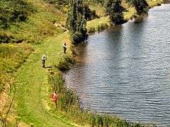
 Westlow Mere, Hulme Walfield |
|
 Hulme Walfield |
|
| Population | 148 (148) |
|---|---|
| OS grid reference | SJ848651 |
| Civil parish | Hulme Walfield |
| Unitary authority | Cheshire East |
| Ceremonial county | Cheshire |
| Region | North West |
| Country | England |
| Sovereign state | United Kingdom |
| Post town | CONGLETON |
| Postcode district | CW12 |
| Dialling code | 01260 |
| Police | Cheshire |
| Fire | Cheshire |
| Ambulance | North West |
| EU Parliament | North West England |
| UK Parliament | Congleton |
Coordinates: 53°10′58″N 2°13′43″W / 53.182778°N 2.228679°W
Hulme Walfield is a small village and civil parish, just north of Congleton, in the unitary authority of Cheshire East and the ceremonial county of Cheshire. It is home to most of Westlow Mere. According to the 2001 census, the population of the civil parish was 140,[1] increasing slightly to 148 at the 2011 Census[2]
Governance
Because of its small size, it has a grouping arrangement with the adjacent civil parish of Somerford Booths and holds joint parish council meetings. The parish council is therefore known as Hulme Walfield & Somerford Booths parish council.[3]
See also
References
- ↑ 2001 Census figures for Hulme Walfield civil parish. Neighbourhood Statistics. Official UK government website. Retrieval Date: February 11, 2008.
- ↑ "Civil Parish population 2011". Neighbourhood Statistics. Office for National Statistics. Retrieved 14 March 2016.
- ↑ Borough of Congleton Parish Clerks Details. Borough of Congleton Official Website. Retrieval Date: February 11, 2008.
External links
![]() Media related to Hulme Walfield at Wikimedia Commons
Media related to Hulme Walfield at Wikimedia Commons
This article is issued from Wikipedia - version of the 3/14/2016. The text is available under the Creative Commons Attribution/Share Alike but additional terms may apply for the media files.