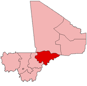
Hombori
| Hombori | |
|---|---|
| Commune and town | |
 | |
 Hombori | |
| Coordinates: 15°16′48″N 1°42′0″W / 15.28000°N 1.70000°WCoordinates: 15°16′48″N 1°42′0″W / 15.28000°N 1.70000°W | |
| Country |
|
| Region | Mopti Region |
| Cercle | Douentza |
| Area | |
| • Total | 2,923 km2 (1,129 sq mi) |
| Population (2009 census)[1] | |
| • Total | 23,099 |
| • Density | 7.9/km2 (20/sq mi) |
Hombori is a small town and rural commune in the Cercle of Douentza in the Mopti Region of Mali. The commune contains 25 villages and in the 2009 census had a population of 23,099. The town lies just to the north of the Hombori Tondo mesa on the R15 highway linking Mopti and Gao.
Climate
Nearly all the rainfall occurs between late June and the middle of September.[2] The mean annual rainfall in the period 1950-2007 was 372 mm but there are large year-to-year variations. The mean air temperature is 30.2 °C with the highest monthly average occurring in May (42 °C) and the lowest in January (17.1 °C). The provision of drinking water in the commune is difficult as there is no continuous aquifer which can be tapped by deep wells.[2]
| Climate data for Hombori (1961–1990) | |||||||||||||
|---|---|---|---|---|---|---|---|---|---|---|---|---|---|
| Month | Jan | Feb | Mar | Apr | May | Jun | Jul | Aug | Sep | Oct | Nov | Dec | Year |
| Average high °C (°F) | 31.5 (88.7) |
34.8 (94.6) |
38.1 (100.6) |
41.0 (105.8) |
42.3 (108.1) |
40.5 (104.9) |
37.0 (98.6) |
35.3 (95.5) |
37.1 (98.8) |
39.0 (102.2) |
36.1 (97) |
32.1 (89.8) |
37.1 (98.8) |
| Daily mean °C (°F) | 24.8 (76.6) |
27.4 (81.3) |
30.6 (87.1) |
33.4 (92.1) |
35.5 (95.9) |
34.2 (93.6) |
31.2 (88.2) |
29.6 (85.3) |
30.8 (87.4) |
31.9 (89.4) |
28.6 (83.5) |
25.1 (77.2) |
30.3 (86.5) |
| Average low °C (°F) | 16.7 (62.1) |
19.2 (66.6) |
22.6 (72.7) |
26.0 (78.8) |
28.8 (83.8) |
27.8 (82) |
25.2 (77.4) |
24.3 (75.7) |
24.6 (76.3) |
24.5 (76.1) |
20.7 (69.3) |
17.1 (62.8) |
23.1 (73.6) |
| Average precipitation mm (inches) | 0.0 (0) |
0.1 (0.004) |
0.6 (0.024) |
2.9 (0.114) |
8.7 (0.343) |
37.8 (1.488) |
103.2 (4.063) |
109.5 (4.311) |
57.0 (2.244) |
12.9 (0.508) |
0.0 (0) |
0.3 (0.012) |
333.0 (13.11) |
| Average precipitation days | 0.0 | 0.1 | 0.4 | 0.4 | 1.0 | 5.2 | 8.1 | 9.8 | 7.7 | 1.8 | 0.0 | 0.1 | 34.6 |
| Mean monthly sunshine hours | 270.0 | 252.5 | 257.3 | 245.8 | 261.7 | 231.0 | 242.4 | 252.0 | 242.4 | 270.6 | 204.5 | 258.3 | 2,988.5 |
| Source: NOAA[3] | |||||||||||||
Sites and fame
The town is known for its vernacular architecture of rock-built houses with narrow alleyways and tunnels. The area around Hombori features rock formations including the Needles of Gami and is popular for rock climbing. Mount Hombori, Mali's highest point at 1153 meters, is nearby.
History
Hombori is an ancient village of the Dogon people; its exact age is unknown. After the invasion of the almoravides in the 16th century, one part of the royal family of Gao established themselves in Hombori. The Songhai, now the majority population, later followed the royal refugees to this area.

Hombori remains a focus of Songhai Empire traditions but was also a strategic point for the conquest of southern Mali by the Songhai successor states.
Those local villages deeper in the hills (for example Tabi, 30 km away) were never conquered or directly colonised, and retain their traditional cultures.
The Songhai leadership were largely coopted by the French Colonial administration upon their arrival around 1900, while much of the Dogon community fled to nearby mountains, a process that had earlier begun to escape Moorish slave raids.
The religion of the community is Islam by a vast majority. Sufism and Shiism are the dominant belief systems in the area.
Some sequences of Souleymane Cissé's film, Yeelen, were shot in Hombori.
References
- ↑ Resultats Provisoires RGPH 2009 (Région de Mopti) (PDF) (in French), République de Mali: Institut National de la Statistique.
- 1 2 Mougin, E.; et al. (2009), "The AMMA-CATCH Gourma observatory site in Mali: Relating climatic variations to changes in vegetation, surface hydrology, fluxes and natural resources" (PDF), Journal of Hydrology, 375: 14–33, doi:10.1016/j.jhydrol.2009.06.045.
- ↑ "Hombori Climate Normals 1961–1990". National Oceanic and Atmospheric Administration. Retrieved 19 October 2015.
External links
- Plan de Sécurité Alimentaire Commune Rurale de Hombori 2006-2010 (PDF) (in French), Commissariat à la Sécurité Alimentaire, République du Mali, USAID-Mali, 2006.
- Situation des points d'eau modernes au Mali en 2003: Hombori (in French), Ministère des Mines, de l'Energie et de l'Eau, République du Mali, 2003.
- Project Hombori
