Habana, Queensland
| Habana Queensland | |||||||||||||
|---|---|---|---|---|---|---|---|---|---|---|---|---|---|
 Habana | |||||||||||||
| Coordinates | 21°01′13″S 149°04′27″E / 21.02028°S 149.07417°ECoordinates: 21°01′13″S 149°04′27″E / 21.02028°S 149.07417°E | ||||||||||||
| Population | 925 (2011 census)[1] | ||||||||||||
| Postcode(s) | 4740 | ||||||||||||
| Location |
| ||||||||||||
| LGA(s) | Mackay Region | ||||||||||||
| State electorate(s) | Whitsunday | ||||||||||||
| Federal Division(s) | Dawson | ||||||||||||
| |||||||||||||
Habana is a coastal locality in the Mackay Region, Queensland, Australia.[2] In the 2011 census, Habana had a population of 925 people.[1]
History

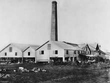
Habana Sugar Mill, 1895
The locality takes its name from La Habana sugar plantation established by Edward Maitland Long and William Robertson in 1881 on 6000 acres of land already owned by Long. They built the Habana sugar mill in 1883 and it operated until 1901.[3]
Heritage listings
Habana has a number of heritage-listed sites, including:
- Between Habana Wharf Road and Constant Creek: Habana Tramline Causeway and Wharf Site[4]
References
- 1 2 Australian Bureau of Statistics (31 October 2012). "Habana". 2011 Census QuickStats. Retrieved 2 January 2016.
- ↑ "Habana (entry 46792)". Queensland Place Names. Queensland Government. Retrieved 2 January 2016.
- ↑ "Habana Sugar Mill, 1883-1902". www.mackayhistory.org. Retrieved 2016-01-02.
- ↑ "Habana Tramline Causeway and Wharf Site (entry 602749)". Queensland Heritage Register. Queensland Heritage Council. Retrieved 10 July 2013.
External links
![]() Media related to Habana, Queensland at Wikimedia Commons
Media related to Habana, Queensland at Wikimedia Commons
- "Habana". Queensland Places. Centre for the Government of Queensland, University of Queensland.
This article is issued from Wikipedia - version of the 1/3/2016. The text is available under the Creative Commons Attribution/Share Alike but additional terms may apply for the media files.