Great Mis Tor
| Great Mis Tor | |
|---|---|
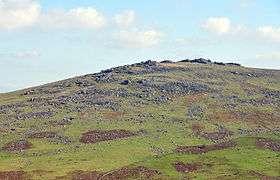 Great Mis Tor, seen from the neighbouring Roos Tor | |
| Highest point | |
| Elevation | 538 m (1,765 ft) |
| Prominence | 80m |
| Listing | Dewey |
| Coordinates | 50°34′30″N 4°01′51″W / 50.57500°N 4.03083°WCoordinates: 50°34′30″N 4°01′51″W / 50.57500°N 4.03083°W |
| Geography | |
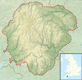 Great Mis Tor Location of Great Mis Tor in Dartmoor | |
| Location | Devon, England |
| Parent range | Dartmoor, |
| OS grid | SX563770 |
| Topo map | OS Landrangers 191, Explorer OL28 |
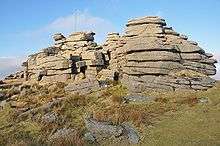
Rock outcropping at the summit. The flagpole is used when military exercises are taking place on the moors.
Great Mis Tor is a hill with a rocky outcrop situated in Dartmoor. It has been called one of the grandest hills in Devon,[1] and lies above the River Walkham, about 4 miles north-east of Princetown.
There is a notable rock basin on the peak, called the Mis Tor Pan or The Devil's Frying Pan.[2]
The hill and surrounding area is on land owned by the Duchy of Cornwall, which is leased to the army. There have been cases of deaths and injury to the public caused by unexploded munitions in the area.[3]
References
Bibliography
- Doyle, Leonard (June 20, 1995), "Children injured in new bomb accident in National Park", The Independent, retrieved February 8, 2010
- Hemery, Eric (1983), High Dartmoor, London: Hale Publishing
- Murray, John (1865), A handbook for travellers in Devon and Cornwall, London: W. Clowes and Sons
This article is issued from Wikipedia - version of the 11/6/2016. The text is available under the Creative Commons Attribution/Share Alike but additional terms may apply for the media files.