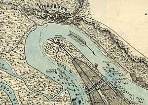
Grant's Canal

Grant's Canal was located near Delta, Louisiana. Ulysses S. Grant ordered the project, started on June 27, 1862, with two goals in mind. The first was to alter the course of the Mississippi River in order to bypass the Confederate guns at Vicksburg, Mississippi. For various technical reasons the project failed to meet this goal. The river did change course by itself on April 26, 1876. But the project did meet its second goal, keeping troops occupied during the laborious maneuvering required to begin the Battle of Vicksburg. A small remnant of the canal is part of Vicksburg National Military Park.
History
During the summer of 1862, as the ships of the West Gulf Blockading Squadron under Flag Officer David Glasgow Farragut bombarded the Vicksburg river defenses, a 3,000-man infantry brigade commanded by Brig. Gen. Thomas Williams began work on this canal across the base of De Soto Point on the west side of the Mississippi River across from Vicksburg. The purpose of the canal was to develop a channel for navigation that would enable gunboats and transports to bypass the Confederate batteries at Vicksburg.
It was thought that the scouring effect of the Mississippi River's current would keep the canal open. Some believed that the man-made channel would possibly even catch enough of the currents force to cause the river to change course, leaving Vicksburg high and dry and making it worthless militarily without firing a shot. Work on the canal commenced on June 27, 1862, as soldiers from Connecticut, Massachusetts, Vermont, Wisconsin, and Michigan began felling trees, grubbing roots, and excavating dirt. Heat exhaustion, sunstroke, and disease took a heavy toll of human life. To augment his fast-dwindling workforce, Williams employed some 1,100-1,200 African-Americans that had been gathered from neighboring plantations by armed parties. In spite of the heat, the canal was excavated to a depth of 13 feet (4.0 m) and a width of 18 feet (5.5 m). However, the Mississippi River dropped faster than the Union could dig.[1] By July 24, work on the canal stopped and Williams' weary soldiers accompanied the West Gulf Blockading Squadron as Farragut withdrew southward to safer water.
In January 1863, work on the canal was resumed by troops under the command of Maj. Gen. Ulysses S. Grant. Although placing little confidence in the success of the project, Grant approved of the idea as it would keep his soldiers in good physical condition for the spring campaign, and more importantly, keep the spirit of the offensive alive.[2]
As the soldiers and African-Americans that had been pressed into service dug lower, there was a sudden rise in the river that broke through the dam at the head of the canal and flooded the area. In a desperate effort to rescue the project, two huge steam-driven dipper dredges, Hercules and Sampson, were put to work clearing the channel. The dredges, however, were exposed to Confederate artillery fire from the bluffs at Vicksburg and were driven away. By late March, Grant had decided to make a bold change in his Vicksburg campaign operations and work on the canal was abandoned.
Present day
Grant's Canal has national significance as part of Vicksburg National Military Park and because its construction comprised military activity that had an observable influence on the direction and conduct of the Vicksburg campaign. Although the efforts to construct the canal ended in failure, they are associated with early Federal campaign plans to eliminate the Confederate presence at Vicksburg.
Much of Williams' Canal/Grant's Canal has been obliterated by agricultural operations since the Civil War. This is the only segment that retains its original width and much of its depth. The 2.5-acre (10,000 m2) tract was donated to the National Park Service by local landowners working in conjunction with The Conservation Fund and became part of Vicksburg National Military Park in 1990. Thus, the National Park Service currently protects and interprets the resources.
See also
- Dutch Gap, a similar attempt in 1864 on the James River.
References
- ↑ David F. Bastian (1995). "Grant's Canal the Union's attempt to bypass Vicksburg". Burd Street Press.
- ↑ Louisiana Department of Culture, Recreation and Tourism. "Grant's Canal Historical Marker". Retrieved August 9, 2009.
http://www.rootsweb.ancestry.com/~lamadiso/articles/canals.htm
Grant's Canal, the Union's Attempt to Bypass Vicksburg, David F. Bastian, Burd Street Press, 1995
Coordinates: 32°19′14″N 90°56′0″W / 32.32056°N 90.93333°W
![]() This article incorporates public domain material from the National Park Service document "".
This article incorporates public domain material from the National Park Service document "".