Grade II* listed buildings in North Kesteven
There are over 20,000 Grade II* listed buildings in England. This page is a list of these buildings in the district of North Kesteven in Lincolnshire.
North Kesteven
| Name | Location | Type | Completed [note 1] | Date designated | Grid ref.[note 2] Geo-coordinates |
Entry number [note 3] | Image |
|---|---|---|---|---|---|---|---|
| Church of St Oswald | Howell, Asgarby and Howell, North Kesteven | Cross | 10th century | 1 February 1967 | TF1350746256 53°00′06″N 0°18′36″W / 53.001604°N 0.310021°W |
1061833 |  |
| Churchyard Cross in the Churchyard of St Oswald's Church | Howell, Asgarby and Howell, North Kesteven | Cross | 15th century | 12 October 1988 | TF1350646243 53°00′05″N 0°18′36″W / 53.001487°N 0.31004°W |
1168431 |  |
| Church of St Hybald | Ashby de la Launde and Bloxholm, North Kesteven | Parish Church | 12th century | 1 February 1967 | TF0551054754 53°04′47″N 0°25′35″W / 53.079597°N 0.426359°W |
1307159 |  |
| Parish Church of St Mary and All Saints | Aswarby and Swarby, North Kesteven | Church | 13th century | 1 February 1967 | TF0470740568 52°57′08″N 0°26′35″W / 52.952283°N 0.442938°W |
1147542 | 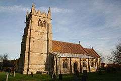 |
| Church of St Peter | Aubourn and Haddington, North Kesteven | Parish Church | 13th century | 23 August 1967 | SK9276762787 53°09′15″N 0°36′51″W / 53.154147°N 0.614207°W |
1360541 |  |
| Parish Church of St Thomas a Becket | Aunsby, Aunsby and Dembleby, North Kesteven | Church | 12th century | 1 February 1967 | TF0447038838 52°56′12″N 0°26′49″W / 52.936783°N 0.447021°W |
1061790 |  |
| Church of St Michael and All Angels | Bassingham, North Kesteven | Parish Church | 11th century | 23 August 1967 | SK9080659732 53°07′37″N 0°38′40″W / 53.127031°N 0.644388°W |
1061923 |  |
| Church of St Oswald | Blankney, North Kesteven | Parish Church | 12th century | 1 February 1967 | TF0682660003 53°07′35″N 0°24′18″W / 53.126501°N 0.404978°W |
1064285 | |
| Church of All Saints | Branston and Mere, North Kesteven | Schoolroom | 1836 | 23 August 1967 | TF0213067313 53°11′35″N 0°28′22″W / 53.193106°N 0.4728°W |
1360529 | 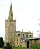 |
| Lister Place, Gates and Gatepiers | Brant Broughton and Stragglethorpe, North Kesteven | House | c. 1700 | 17 June 1986 | SK9157854087 53°04′34″N 0°38′04″W / 53.076171°N 0.634462°W |
1061928 | 
|
| The Priory, Gates and Gatepiers | Brant Broughton and Stragglethorpe, North Kesteven | House | 1658 | 23 August 1967 | SK9153554027 53°04′32″N 0°38′06″W / 53.075639°N 0.63512°W |
1360527 |
|
| Coleby Hall | Coleby, North Kesteven | House | 17th century | 19 November 1951 | SK9732260768 53°08′07″N 0°32′48″W / 53.135193°N 0.546727°W |
1061979 |
|
| College Hall, Royal Air Force College Cranwell | Cranwell and Byard's Leap, North Kesteven | Military College | 1929-33 | 7 December 1987 | SK9997349919 53°02′14″N 0°30′38″W / 53.037214°N 0.510486°W |
1254079 |  |
| Culverthorpe Temple | Culverthorpe Park, Culverthorpe and Kelby, North Kesteven | Temple | c. 1740 | 11 January 1990 | TF0231540456 52°57′06″N 0°28′43″W / 52.951737°N 0.478563°W |
1308442 |
|
| The Garages to Culverthorpe Hall | Culverthorpe and Kelby, North Kesteven | Service Wing | Late 17th century | 23 November 1951 | TF0206240354 52°57′03″N 0°28′56″W / 52.950869°N 0.482359°W |
1360582 |
|
| The Stables to Culverthorpe Hall | Culverthorpe Park, Culverthorpe and Kelby, North Kesteven | Stable | Late 17th century | 23 November 1951 | TF0197440347 52°57′03″N 0°29′01″W / 52.950822°N 0.483671°W |
1147621 |
|
| Gatehouse to Doddington Hall | Doddington and Whisby, North Kesteven | Gatehouse | 16th century | 22 December 1983 | SK9005470080 53°13′13″N 0°39′10″W / 53.22015°N 0.652713°W |
1360505 |  |
| Walls and Gates to Doddington Hall | Doddington and Whisby, North Kesteven | Gate Pier | 16th century | 22 December 1983 | SK8994370086 53°13′13″N 0°39′16″W / 53.220223°N 0.654373°W |
1061959 |
|
| The Jungle | Eagle and Swinethorpe, North Kesteven | Farmhouse | c. 1820 | 7 September 1977 | SK8835268597 53°12′26″N 0°40′43″W / 53.207109°N 0.678607°W |
1061998 |
|
| Church of St Mary | Evedon, Ewerby and Evedon, North Kesteven | Parish Church | 13th century | 1 February 1967 | TF0928347594 53°00′52″N 0°22′21″W / 53.014504°N 0.372484°W |
1168557 |  |
| All Saints Parish Church | Harmston, North Kesteven | Parish Church | 11th century | 23 August 1967 | SK9727162275 53°08′55″N 0°32′49″W / 53.148744°N 0.547033°W |
1164892 | 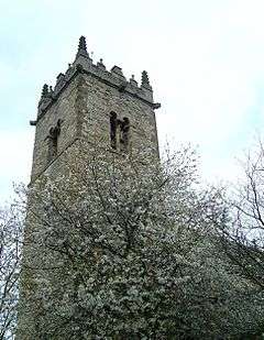 |
| Harmston Hall Hospital | Harmston, North Kesteven | Country House | 1710 | 23 August 1967 | SK9699462141 53°08′51″N 0°33′04″W / 53.14759°N 0.551213°W |
1317567 |
|
| Manor Farmhouse | Helpringham, North Kesteven | House | Late 17th century | 12 October 1988 | TF1400740730 52°57′07″N 0°18′16″W / 52.951845°N 0.304518°W |
1061814 |
|
| Church of St Denys | Kirkby la Thorpe, North Kesteven | Parish Church | 12th century | 1 February 1967 | TF0990746092 53°00′03″N 0°21′49″W / 53.00088°N 0.363698°W |
1360592 |  |
| The Grange | Kirkby la Thorpe, North Kesteven | House | c. 1620 | 1 February 1967 | TF0979146190 53°00′06″N 0°21′55″W / 53.001784°N 0.365392°W |
1168986 |
|
| Leadenham House | Leadenham, North Kesteven | Country House | 1790-9 | 23 August 1967 | SK9493651823 53°03′19″N 0°35′06″W / 53.05524°N 0.58502°W |
1061877 |  |
| The Old Hall | Leadenham, North Kesteven | Country House | c. 1600 | 23 August 1967 | SK9518452501 53°03′41″N 0°34′52″W / 53.061289°N 0.581121°W |
1061869 |
|
| The Manor | Leasingham, North Kesteven | Country House | c. 1750 | 1 February 1967 | TF0572648348 53°01′19″N 0°25′31″W / 53.021992°N 0.425236°W |
1261371 |
|
| Church of St Wilfred | Metheringham, North Kesteven | Parish Church | 12th century | 2 May 1985 | TF0701761288 53°08′17″N 0°24′06″W / 53.138009°N 0.401696°W |
1165640 | .jpg) |
| Church of All Saints | Nocton, North Kesteven | Parish Church | 1862 | 23 August 1967 | TF0606764125 53°09′49″N 0°24′54″W / 53.163691°N 0.414953°W |
1061911 |  |
| Field House and Wall to Nocton Hall | Nocton, North Kesteven | House | Late 18th century | 4 December 1979 | TF0594664261 53°09′54″N 0°25′00″W / 53.164937°N 0.416717°W |
1061910 |
|
| Rowston Manor | Rowston, North Kesteven | House | 1741 | 1 February 1967 | TF0835656408 53°05′38″N 0°23′00″W / 53.09389°N 0.383335°W |
1280659 |
|
| Church of the Holy Cross | Scopwick, North Kesteven | Parish Church | 12th century | 1 February 1967 | TF0698558056 53°06′32″N 0°24′12″W / 53.108975°N 0.403251°W |
1064299 |  |
| Cross Base | Silk Willoughby, North Kesteven | Cross | 14th century | 1 February 1967 | TF0565042969 52°58′25″N 0°25′41″W / 52.973673°N 0.428125°W |
1360612 |  |
| Carre's Hospital. Pump and Sun-dial in the Forecourt and Wall Along Carre Street | Sleaford, North Kesteven | House | 1841-1846 | 16 July 1949 | TF0691745851 52°59′58″N 0°24′30″W / 52.999319°N 0.408313°W |
1062145 |
|
| Church of St Botolph | Quarrington, Sleaford, North Kesteven | Church | Late 12th century | 16 July 1949 | TF0541144468 52°59′14″N 0°25′52″W / 52.98719°N 0.431195°W |
1360452 | 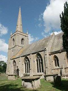 |
| Manor House, Rhodes House, Wall and Gate Piers to Cobbled Yard and Garden Wall to No 33 | Sleaford, North Kesteven | House | 16th century | 16 July 1949 | TF0676846001 53°00′03″N 0°24′38″W / 53.000696°N 0.410483°W |
1168499 |
|
| Town Hall (Sessions House) | Sleaford, North Kesteven | Town Hall | 1831 | 16 July 1949 | TF0679545870 52°59′58″N 0°24′36″W / 52.999514°N 0.410124°W |
1307024 |
|
| Vicarage | Sleaford, North Kesteven | Vicarage | 15th century | 16 July 1949 | TF0686845924 53°00′00″N 0°24′32″W / 52.999985°N 0.409019°W |
1168389 |
|
| Church of St Michael | South Hykeham, North Kesteven | Parish Church | 13th century | 22 December 1983 | SK9368564539 53°10′11″N 0°36′00″W / 53.169731°N 0.599972°W |
1061957 | 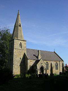 |
| Church of St Mary and All Saints | South Kyme, North Kesteven | Parish Church | 1890 | 1 February 1967 | TF1685449788 53°01′57″N 0°15′32″W / 53.03262°N 0.258893°W |
1061749 |  |
| Church of All Saints | Swinderby, North Kesteven | Church | 12th century | 23 August 1967 | SK8690263179 53°09′31″N 0°42′06″W / 53.158658°N 0.701782°W |
1165316 |  |
| Church of St Germain | Thurlby, North Kesteven | Parish Church | 11th century | 23 August 1967 | SK9089561713 53°08′41″N 0°38′33″W / 53.144818°N 0.642497°W |
1061972 |  |
| Church of St Andrew | Timberland, North Kesteven | Church | C20 | 1 February 1967 | TF1217058242 53°06′34″N 0°19′33″W / 53.109582°N 0.325765°W |
1205586 |  |
| Church of St John the Evangelist | Washingborough, North Kesteven | Parish Church | 13th century | 23 August 1967 | TF0185270632 53°13′23″N 0°28′33″W / 53.222983°N 0.475902°W |
1205149 | 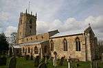 |
| Welbourn Manor | Welbourn, North Kesteven | Country House | Early 14th century | 19 November 1951 | SK9663753982 53°04′28″N 0°33′32″W / 53.074337°N 0.559003°W |
1360567 |
|
| Wellingore Hall and attached R.C. Church of St Augustine | Wellingore, North Kesteven | Apartment | c. 1760 | 23 August 1967 | SK9831256533 53°05′49″N 0°32′00″W / 53.096956°N 0.53323°W |
1147748 |  |
Notes
- ↑ The date given is the date used by Historic England as significant for the initial building or that of an important part in the structure's description.
- ↑ Sometimes known as OSGB36, the grid reference is based on the British national grid reference system used by the Ordnance Survey.
- ↑ The "List Entry Number" is a unique number assigned to each listed building and scheduled monument by Historic England.
External links
![]() Media related to Grade II* listed buildings in Lincolnshire at Wikimedia Commons
Media related to Grade II* listed buildings in Lincolnshire at Wikimedia Commons
This article is issued from Wikipedia - version of the 8/31/2016. The text is available under the Creative Commons Attribution/Share Alike but additional terms may apply for the media files.