Pinellas Trail
| Fred Marquis Pinellas Trail | |
|---|---|
|
Section of the Pinellas Trail | |
| Length | 38.2 mi (61.5 km) |
| Location | Pinellas County, Florida, United States |
| Trailheads |
Tarpon Springs, Florida St. Petersburg, Florida |
| Use | Cycling, Walking, Hiking, Jogging, Inline Skating |
| Hiking details | |
| Trail difficulty | Easy to Moderate |
| Season | Year round |
| Hazards | Crime |
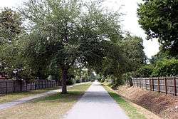
The Fred Marquis Pinellas Trail is a rail trail in Pinellas County, Florida. It stretches from Tarpon Springs in the north to St. Petersburg in the south, passing through the towns of Palm Harbor, Dunedin, Clearwater, Largo, Seminole, South Pasadena, and Gulfport. It is utilized for walking, jogging, cycling, and inline skating. Some trail users are able to commute to work using the Pinellas Trail instead of a motor vehicle.
The distance that the main trail currently covers 38.2 miles (61.5 km).[1]
The Pinellas Trail was named after Fred Marquis, a former Pinellas County Administrator who served from 1979 until 2000.

History
The Seaboard Air Line (SAL) and Atlantic Coast Line (ACL) railroads both served St. Petersburg and Clearwater for many years. They later joined CSX Transportation, who consolidated the existing infrastructure. This resulted in the abandonment of 34 miles worth of trackage, which was purchased by the Florida Department of Transportation. After voter approval, the County acquired the property, and began construction of the Pinellas Trail.
The first five miles (8 km) opened in December 1990, linking Taylor Park to Seminole Park. With the passage of the first Penny for Pinellas one-cent local option sales tax, plans were made to connect the construct additional segments along the railway corridor.

The Pinellas Trail is composed of the following railroad segments:
- former SAL to the east of Tarpon Springs
- former ACL from Tarpon Springs to Clearwater
- former SAL into St. Petersburg
Future
When completed, the Pinellas Trail will extend to 47 miles (76 km) in length.
Hazards
Unlike most rail trails which transverse rural countrysides, the Pinellas Trail travels through several very urban areas.
When traveling through some of the neighborhoods in sections of St. Petersburg and Tarpon Springs, trail users are encouraged to be cautious. In Clearwater, the same warning applies; trail users may have the right-of-way in areas with minimal vehicular traffic, but they do not when the trail crosses a major artery such as State Road 60.

See also
References
External links
| Wikimedia Commons has media related to Pinellas Trail. |
- Official Website
- Pinellas Trails, Inc.
- Florida Department of Environmental Protection: Greenways & Trails
- American Trails
- RailsToTrails.us Page For Pinellas Trail
- About the Pinellas Trail
- Pinellas Trail Guide
- Pinellas County Metropolitan Planning Organization
- A Short History of the Pinellas County Trail System
Coordinates: 27°57′32″N 82°47′49″W / 27.95889°N 82.79694°W
