Five Houses and Lower LaHave
| Five Houses and Lower LaHave | |
|---|---|
| Community | |
|
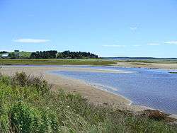
Oxner's Head And Beach from Five Houses | |
 Location of Five Houses, Nova Scotia | |
| Coordinates: 44°16′59.02″N 64°20′14.78″W / 44.2830611°N 64.3374389°WCoordinates: 44°16′59.02″N 64°20′14.78″W / 44.2830611°N 64.3374389°W | |
| Country | Canada |
| Province | Nova Scotia |
| Municipality | Lunenburg Municipality |
| Elevation | 0 m (0 ft) |
| Highest elevation | 119 m (390 ft) |
| Lowest elevation | 0 m (0 ft) |
| Time zone | AST (UTC-4) |
| • Summer (DST) | ADT (UTC-3) |
| Canadian Postal code | B0J 2W0 |
| Area code(s) | 902 |
| Telephone Exchanges | 764, 766 |
| NTS Map | 021A08 |
| GNBC Code | CBFUW |
| Website |
www |
Lower LaHave
Lower LaHave and the smaller area of Five Houses is a small village in Nova Scotia, Canada on the shore of the LaHave River. The community is located in the Lunenburg Municipal District in Lunenburg County.
Lower LaHave and Five Houses Gallery
-
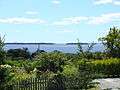
The LaHave Islands From Romkey Hill
-
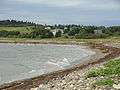
A View of Five Houses From Oxner's Beach
Geography
Lower LaHave covers a vast tracts of undeveloped forest land overlooking the LaHave River banks. It is anchored by history and marked with the Lower LaHave Commons. Part of Lower LaHave Area feature is an area known as The Shoubach. This area after its name sake was granted to Christian Shoubach.
External links
This article is issued from Wikipedia - version of the 10/21/2016. The text is available under the Creative Commons Attribution/Share Alike but additional terms may apply for the media files.