Finnrevet
 Finnrevet Lighthouse | |
 Sweden | |
| Location |
5 nmi (9.3 km) east of Oskarshamn Kalmar County Sweden |
|---|---|
| Coordinates | 57°16′36″N 16°38′04″E / 57.276745°N 16.634482°ECoordinates: 57°16′36″N 16°38′04″E / 57.276745°N 16.634482°E |
| Year first constructed | 1921 |
| Foundation | concrete basement |
| Construction | cast iron |
| Tower shape | cylindrical tower with balcony and lantern |
| Markings / pattern | White and black |
| Height | 14.5 metres (48 ft) |
| Focal height | 15.5 metres (51 ft) |
| Range | 16 nmi (30 km; 18 mi) |
| Characteristic | Fl (2) W 6s. |
| Admiralty number | C7292 |
| NGA number | 8052 |
| Managing agent | Swedish Maritime Administration (Sjöfartsverket)[1] |
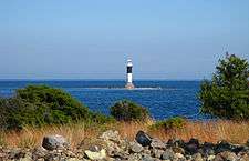
Finnrevet is a Swedish lighthouse located on a shoal about 5 nautical miles outside Oskarshamn in Europe.
General information
The lighthouse was built in 1921 and is located on a reef just east of island Furö. The black and white tower is about 15,5 meters high. The light can be seen at a distance of 16 nmi (30 km).
Wrecks near Finnrevet
The waters around island Furön are shallow and many ships have run aground in the area near the lighthouse.
Shipwrecks in the area:
- Schooner Charlotta wrecked east of Finnrevet 17 May 1882 in a northern gale.[2]
- Russian schooner Lotus av Libau ran aground here in 1898.[3]
- S/S Britkon, cargoship, built 1917 in Sunderland, beached at Finnrevet in November 1949. The steamship had a length of 109 meters, and broke in half after about one month grounded at the reef.[4] The 37 men-crew were rescued by maritime pilots stationed on the nearby island Furön.[5]
- The Hans Olof was a Swedish ship grounded at the reef in due to a sudden north-eastern gale in 1950.
- M/S Priwall, West German flagged cargoship beached at Finnrevet February 1, 1968 loaded with wooden goods.[3]
See also
References
- ↑ Finnrevet The Lighthouse Directory. University of North Carolina at Chapel Hill. Retrieved April 4, 2016
- ↑ Calypso Diving Register of Wrecks
- 1 2 Oskarshamns skolstyrelse: Oskarshamn det egna samhället - Odlare och kustbor, tryckår 1979, s. 59.
- ↑ S/S Britkon on site Association for Hungarian Shipping
- ↑ Article in newspaper Nyheterna
External links
This article is issued from Wikipedia - version of the 5/16/2016. The text is available under the Creative Commons Attribution/Share Alike but additional terms may apply for the media files.