Fedafjorden
| Fedafjorden | |
|---|---|
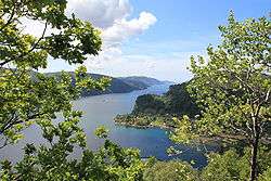 View of the fjord | |
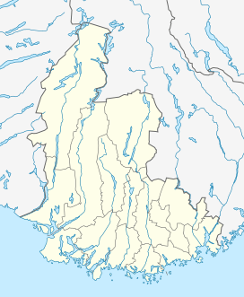 Fedafjorden Location of the fjord  Fedafjorden Location of the fjord | |
| Location | Vest-Agder county, Norway |
| Coordinates | 58°15′29″N 6°49′09″E / 58.2580°N 06.8191°ECoordinates: 58°15′29″N 6°49′09″E / 58.2580°N 06.8191°E |
| Primary inflows | Kvina river |
| Primary outflows | Listafjorden |
| Basin countries | Norway |
| Max. length | 15 kilometres (9.3 mi) |
| Max. width | 1.5 kilometres (0.93 mi) |
| Islands | Andabeløya |
| Settlements | Feda |
Fedafjorden is a fjord in Vest-Agder county, Norway. The 15-kilometre (9.3 mi) is located in the municipalities of Kvinesdal, Flekkefjord, and Farsund. The long, narrow fjord runs south from the mouth of the river Kvina to the Listafjorden.[1]
.jpg)
The fjord is 15 kilometres (9.3 mi) long and only about 1.5 kilometres (0.93 mi) wide. The village of Feda is located at the northwestern side of the fjord, just west of the Fedafjord Bridge on the European route E39 highway. Near the mouth of the fjord, at the south end, lies the island of Andabeløya. The majority of the fjord lies in Kvinesdal municipality, but the mouth of the fjord is split between the municipalities of Flekkefjord and Farsund.[2]
The old municipality of Feda, which existed from 1900 until 1963, encompassed the 66-square-kilometre (25 sq mi) area surrounding both sides of the Fedafjorden.
References
- ↑ Bull, Francis; Tandberg, Erik; Eskeland, Arnold, eds. (1972). "Fedafjorden". Gyldendals store konversasjonsleksikon (in Norwegian). 2 (3rd ed.). Oslo: Gyldendal.
- ↑ Godal, Anne Marit (ed.). "Listafjorden". Store norske leksikon (in Norwegian). Norsk nettleksikon. Retrieved 25 November 2012.