Evans Peninsula
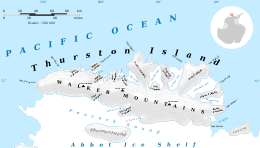

Evans Peninsula (72°1′S 96°47′W / 72.017°S 96.783°WCoordinates: 72°1′S 96°47′W / 72.017°S 96.783°W) is an ice-covered peninsula about 30 nautical miles (60 km) long, between Koether Inlet and Cadwalader Inlet in the northeast part of Thurston Island. Cape Braathen is an ice-covered cape at the northwest termination of Evans Peninsula. It was discovered in flights from the USS Burton Island and USS Glacier by personnel of the U.S. Navy Bellingshausen Sea Expedition in February 1960, and was named by the Advisory Committee on Antarctic Names for Commander Griffith Evans, Jr., commander of the icebreaker Burton Island during this expedition.[1]
Maps
- Thurston Island – Jones Mountains. 1:500000 Antarctica Sketch Map. US Geological Survey, 1967.
- Antarctic Digital Database (ADD). Scale 1:250000 topographic map of Antarctica. Scientific Committee on Antarctic Research (SCAR), 1993–2016.
References
- ↑ "Evans Peninsula". Geographic Names Information System. United States Geological Survey. Retrieved 2012-03-09.
![]() This article incorporates public domain material from the United States Geological Survey document "Evans Peninsula" (content from the Geographic Names Information System).
This article incorporates public domain material from the United States Geological Survey document "Evans Peninsula" (content from the Geographic Names Information System).