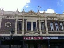
Empire Buildings

The Empire Buildings, also often referred to as the Empire Building, are a group of heritage listed buildings on the corner of Stirling Terrace and York Street overlooking Princess Royal Harbour in Albany in the Great Southern region of Western Australia.
The buildings were constructed in 1912,[1] and once comprised a group of shops and a cinema. The buildings have elements of Federation Free Style architectural design such as asymmetry and use of two contrasting building materials of brick and cement render.[2]
Replacing a single storied bungalow structure that faced York Street,[1] the Empire theatre was designed by architect Tom Anthoness and was built by J. Ashman and Warner.[3] Initially the building held a theatre and shops. The theatre was able to hold 1,000 people.[1] The theatre cost £5,000 and was owned and operated by West's Picture Company. It boasted refreshment stalls, a winter garden for ladies and a spacious dress circle.[4]
Features of the two storey building include a corner entrance, asymmetrical facade, parapet wall concealing roof, informal groupings of windows, gabled pediment and decorative skyline features.[1]
In 2000 a portion of the building was converted to a nightclub.[2] It was closed for some time and reopened to include a bar on the ground floor in 2006.[5]
See also
References
- 1 2 3 4 "Empire Buildings". Heritage Council of Western Australia. Retrieved 12 May 2016.
- 1 2 "City of Albany Municipal Heritage Inventory Review Volume III of IV" (PDF). City of Albany. 1994. Retrieved 14 May 2016.
- ↑ "The Advertiser.". Albany Advertiser. XXIV, (3097). Western Australia. 26 October 1912. p. 3. Retrieved 15 May 2016 – via National Library of Australia.
- ↑ "Princess Pavillion". WA Cinemaweb. Retrieved 15 May 2016.
- ↑ "Albany council approves nightclub re-opening". Australian Broadcasting Corporation. 21 August 2006. Retrieved 16 May 2016.
Coordinates: 35°01′36″S 117°53′02″E / 35.02672°S 117.88394°E