Dyserth railway station
| Dyserth railway station | |
|---|---|
| Location | |
| Coordinates | 53°18′10″N 3°24′24″W / 53.30279°N 3.406773°WCoordinates: 53°18′10″N 3°24′24″W / 53.30279°N 3.406773°W |
| Grid reference | SJ063793 |
| Operations | |
| Pre-grouping | London and North Western Railway |
| Post-grouping | London, Midland and Scottish Railway |
| Platforms | 1 |
| History | |
| 28 Aug 1905 | Opened |
| 22 Sep 1930 | Closed to passengers |
| 4 May 1964 | Closed (except trains to quarry) |
| 1973 | completely closed |
| Disused railway stations in the United Kingdom | |
|
Closed railway stations in Britain A B C D–F G H–J K–L M–O P–R S T–V W–Z | |
|
| |
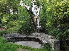
Dyserth railway station was the final stop and terminus on Dyserth branch line (now a footpath) serving the village of Dyserth, Flintshire (now Denbighshire). At its peak Dyserth had passengers in the thousands. It closed down for passengers (along the rest of the line) due to the competition of road vehicles such as cars and buses. 14 trains in both directions would go up and down this line at one point. Although long since demolished, a crane from the station has been installed at the end of the walk as a feature of historical interest (much like the two pieces of track Chapel Street).
The branch line to Dyserth was opened by the LNWR in 1869, initially for mineral traffic only. A passenger service was instituted in 1905 but lasted only until 1930, when it was withdrawn by the LMS. The line remained open to serve a quarry at Dyserth until complete closure in 1973.
References
- ↑ "Visit Prestatyn - Railway Line History". http://www.visitprestatyn.com. Retrieved 23 March 2009. External link in
|publisher=(help)