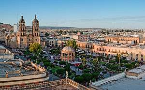
Durango City
| Victoria de Durango | |
|---|---|
| City | |
| City of Durango | |
|
Panoramic view | |
| Nickname(s): Tierra del Cine (Movie Land) | |
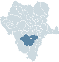 Location of Durango within the State | |
 Victoria de Durango Location in Mexico | |
| Coordinates: 24°01′N 104°40′W / 24.017°N 104.667°WCoordinates: 24°01′N 104°40′W / 24.017°N 104.667°W | |
| Country | Mexico |
| State | Durango |
| Municipality | Durango |
| Founded | July 8, 1563 |
| Founded by | Francisco de Ibarra |
| Government | |
| • Mayor | Esteban Villegas Villareal |
| Elevation | 1,880 m (6,170 ft) |
| Population (2010) | |
| • Total | 518,709 |
| • Demonym | Duranguense/Durangueño |
| Time zone | CST (UTC−6) |
| • Summer (DST) | CDT (UTC−5) |
| Website | http://www.municipiodurango.gob.mx/ |
Durango, officially Victoria de Durango and also known as Ciudad de Durango, is the capital and largest city of the Mexican state of Durango. It stands at an altitude of 1,880 metres (6,168 feet) above sea level.[1]
The city was founded on July 8, 1563 by Spanish Basque explorer Francisco de Ibarra. During the Spanish colonial era the city was the capital of the Nueva Vizcaya province of New Spain, which consisted mostly of the present day states of Durango and Chihuahua.
As of 2010, the city had a total population of 518,709,[2] up from 463,830 as of 2005. It serves as municipal seat of Durango Municipality which had a population of 582,267 in 2010.[2] The municipality has a relatively large land area of 10,041 square kilometres (3,877 square miles) and includes such outlying communities as El Nayar and Cinco de Mayo.
History
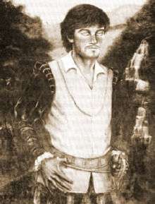
The city of Durango was built on a wide valley in which a primitive Spanish village named Nombre de Dios was founded. By the 16th century, the first conquerors who crossed through its territory were Cristobal de Oñate, José Angulo and Gines Vazquez del Mercado, the latter attracted by the illusion of the existence of a large supply of silver; he had ultimately discovered a special deposit of iron, which now bears his name. In 1562 Don Francisco de Ibarra, the son of one of the celebrated founders of Zacatecas, explored the region and founded the Villa de Guadiana, near the old settlement of Nombre de Dios which soon became known as the Nueva Vizcaya in memory of the western Basque area he was originating from, then called Biscay. Due to untamed territory and also to prevent a reduction in population, Ibarra bought a mine that offered the Indigenous peoples and the Spanish explorers work, with the sole condition that they in turn would settle in the new-founded city.
As in the colonial history of many cities, the founding of Durango is not exempt from the participation of many historical figures, some of which, in addition to Don Francisco de Ibarra, were the scribe Don Sebastian Quiroz, who produced the first correspondence record, the lieutenant Martin Renteria, who carried the banner of conquest, and the captain's Alonso Pacheco, Martín López de Ibarra, Bartolome de Arreola and Martín de Gamon.[3]
According to the 1921 Mexican census, the city had a population of 67,456 out of which 21,300 were European immigrants.
Geography
The city of Durango is located in the northwestern part of the country, and Midwestern part of the Mexican plateau. It is between 22 ° 40 'and 26 ° 50' north latitude and between the meridian 102 ° 25 '55 "and 107 ° 08'50" west latitude relative to Greenwich. To the north it borders the municipalities of Canatlan, and Panuco de Coronado; In the northwest, Guadalupe Victoria;to the south Pueblo Nuevo and Mezquital;to the east Nombre de Dios and Poanas, and to the west the municipalities of Pueblo Nuevo and San Dimas. The municipality is 10.041 square kilometers. Its longest measured lengths are 520 kilometers and 480 kilometers from east to west.
Climate
The city of Durango has a semi-arid climate, classified as BSk in the Köppen climate classification system.[4] The climate is temperate in the western portion (the mountainous region), with the average annual temperature being 15 °C (59 °F) and an average annual rainfall of 1,600 millimetres (63 in). In the eastern region, the average annual temperature is 19 °C (66 °F) and precipitation amounts to 500 millimetres (20 in).
Winters are mild, with an average daytime high of 21 °C (70 °F) in January, the coldest month.[5] As a result of the high altitude and aridity during the winter months, the diurnal temperature range is large, resulting in cold nights (an average low of 1 °C (34 °F) in January). Frosts are common in winter. Occasionally, temperatures can go above 30 °C (86 °F) while cold fronts from the north can push temperatures below −5 °C (23 °F). During the winter months, the climate is dominated by the subtropical ridge, resulting in dry conditions (averaging only 45%) and many days are clear and sunny, averaging around 10-14 clear days.[6][7] Precipitation is rare, with March being the driest month.[5]
Summers are warm to hot with June being the hottest month, with an average high of 30 °C (86 °F) and a low of 14 °C (57 °F).[5] Most of the precipitation falls during the summer months, when the monsoon moves northward, causing moist air from the Gulf of California and Gulf of Mexico to move into the area, leading to many days with precipitation.[7] Generally, this usually occurs around in mid-June.[7] Afternoon storms are common in the summer and they can be accompanied with hail or thunderstorms.[5][6] July and August have warm temperatures, averaging 28 °C (82 °F) though slightly cooler due to the presence of the rain. Humidity tends to be higher during the summer months, averaging 60% from June to September.[6]
The months of March–April and from October to November are transitional months with warm temperatures during the day and cool temperatures during the night with occasional precipitation.
On average, Durango receives 529 millimetres (20.8 in) of precipitation per year and there are 59 days with measureable precipitation. The wettest month recorded was August 1973 with 277.2 millimetres (10.9 in) and the record rainfall for a single day is 108.5 millimetres (4.3 in) on September 15, 1994.[5] The city's weather data for the years 1911 to 2010 are the following; the extreme temperatures are −12 °C (10 °F) on January 15, 1951 and 39.5 °C (103.1 °F) on May 28, 1980.[5] On average, Durango receives 2661 hours of sunshine per year, ranging from a low of 173 hours (or 5.6 hours of sunshine per day) in December to a high of 265 hours in May (8.5 hours of sunshine per day).[6]
| Climate data for Victoria de Durango (1951–2010) | |||||||||||||
|---|---|---|---|---|---|---|---|---|---|---|---|---|---|
| Month | Jan | Feb | Mar | Apr | May | Jun | Jul | Aug | Sep | Oct | Nov | Dec | Year |
| Record high °C (°F) | 32.0 (89.6) |
32.0 (89.6) |
36.0 (96.8) |
36.0 (96.8) |
39.5 (103.1) |
38.0 (100.4) |
34.0 (93.2) |
36.8 (98.2) |
37.0 (98.6) |
34.0 (93.2) |
35.0 (95) |
32.0 (89.6) |
39.5 (103.1) |
| Average high °C (°F) | 20.5 (68.9) |
22.1 (71.8) |
24.5 (76.1) |
27.2 (81) |
30.0 (86) |
30.4 (86.7) |
28.0 (82.4) |
27.6 (81.7) |
26.7 (80.1) |
25.6 (78.1) |
23.0 (73.4) |
20.5 (68.9) |
25.5 (77.9) |
| Daily mean °C (°F) | 10.9 (51.6) |
12.2 (54) |
14.9 (58.8) |
17.7 (63.9) |
20.6 (69.1) |
22.2 (72) |
21.0 (69.8) |
20.7 (69.3) |
19.4 (66.9) |
17.4 (63.3) |
14.0 (57.2) |
11.3 (52.3) |
16.9 (62.4) |
| Average low °C (°F) | 1.3 (34.3) |
2.4 (36.3) |
5.3 (41.5) |
8.2 (46.8) |
11.1 (52) |
14.0 (57.2) |
14.0 (57.2) |
13.7 (56.7) |
12.2 (54) |
9.1 (48.4) |
5.0 (41) |
2.1 (35.8) |
8.2 (46.8) |
| Record low °C (°F) | −12.0 (10.4) |
−12.0 (10.4) |
−9.5 (14.9) |
−6.0 (21.2) |
1.4 (34.5) |
3.5 (38.3) |
1.3 (34.3) |
7.0 (44.6) |
2.0 (35.6) |
0.0 (32) |
−6.0 (21.2) |
−10.0 (14) |
−12.0 (10.4) |
| Average precipitation mm (inches) | 11.3 (0.445) |
7.6 (0.299) |
3.8 (0.15) |
6.2 (0.244) |
12.8 (0.504) |
69.3 (2.728) |
121.6 (4.787) |
140.2 (5.52) |
80.7 (3.177) |
51.9 (2.043) |
13.6 (0.535) |
10.0 (0.394) |
529.0 (20.827) |
| Average precipitation days (≥ 0.1 mm) | 1.5 | 0.8 | 0.5 | 1.0 | 1.8 | 8.0 | 14.7 | 14.1 | 8.4 | 4.7 | 1.6 | 1.8 | 58.9 |
| Average relative humidity (%) | 64 | 60 | 55 | 53 | 55 | 64 | 72 | 73 | 71 | 66 | 64 | 66 | 64 |
| Mean monthly sunshine hours | 213 | 234 | 264 | 258 | 288 | 241 | 216 | 216 | 204 | 246 | 257 | 219 | 2,856 |
| Source #1: Servicio Meteorológico Nacional (humidity 1981–2000)[5][8][9] | |||||||||||||
| Source #2: Deutscher Wetterdienst (sun, 1961–1990)[10][lower-alpha 1] | |||||||||||||
Architecture
Durango's architecture is characterized by its eclectic nature, with elements resembling Barcelona, Florence, Paris and Madrid. Spanish and French influences increased after the declaration of independence at the beginning of the 19th century, though the academic style persisted until the first decades of the 20th century.
The city was built on a rectangular street grid during the colonial era; during much of the post-independence period until the mid-20th century the lay-out of the city looked the same as it did in the 17th century and, with the invention of cars and buses the city became a complicated maze of tangling and narrow colonial streets that made the city almost impossible to map. It was not until the 1990s and much of the first decade of the 21st century that the city's government decided to clear some of the narrow colonial-era streets to build parks, plazas, and wider avenues that today continue to act as roads between the city's sprawling "colonias" (neighborhoods).
Palacio de Gobierno
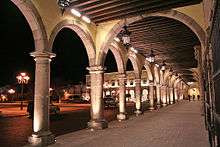
Baroque-style building built in the late 18th century by order of Spanish miner, Juan Jose Zambrano, the wealthiest man in a province of Nueva Vizcaya, New Spain at the time. Made of quarry the building consists of two levels: the first is a portal with voussoir arches, supported by padded ornamental columns. The second level of the portal, showcases the main balcony with a prominent bell; a replica of the "Campana de Dolores". Throughout the interior, paintings by Francisco de la Cruz Montoya, completed on September 15, 1950, as well as works by Esquivel Ernesto Flores completed in April 1981 are on display.
Palacio Municipal
This neoclassical building was built in 1898 as a private residence of Peter Escárzaga, a wealthy Durangueño miner. Inside the building there is a mural painting, by the Durangueño artist Francisco Montoya, of a cross that represents the city's history from its founding until the present time, for example the conquest of Nueva Vizcaya, the discovery of the Cerro del Mercado, the Revolution and the independence movement. This beautiful building is owned by the City of Durango since 1930, when it was purchased to become City Hall.
Casa del Conde de Súchil
Built in the colonial era as a residence of José del Campo Soberón and Larrea,a lieutenant governor of Nueva Vizcaya in the late 18th century, it was built between 1763 and 1764 by a master mason named Pedro Huertas, who gave the house an excellent façade and magnificent baroque interior punctuated by Rococo-style detailing. The whole construction was made with duranguense quarry onto which engravings are stamped to give it a touch of distinction above all other buildings of its kind.
Catedral Basílica Menor

Widely known as "Catedral Basílica de Durango", it is situated in the heart of the city of Durango and is considered the most important architectural representation of the state, and one of the most beautiful buildings in northern Mexico. The original construction began under the leadership of Bishop Garcia Legazpi in the 1695, and designed by architect Mateo Nuñez. The main façade is baroque-style, and includes Corinthian columns and niches built to protect the image of St. Peter and St. Paul. The choir stage, built in the early 18th century is gilded and made of carved mahogany with polychrome styling. The cathedral boasts the second most beautiful richly carved choir stage in the country; second only to that preserved in the Metropolitan Cathedral in Mexico City. The altar formed by a Neoclassical style cypress, guards the image of the Purisima Concepcion; a polychrome and gilded carving of the 18th century. On the altar there are paintings by duranguense artists Miguel Cabrera and Juan Correa.
Culture and Contemporary Life
Entertainment and performing arts
The city of Durango attracts close to one million visitors each summer for its annual month-long Feria Nacional De Durango (Durango's National Festival) which has taken place since 1929. It is the most important festival in the history of the state and the city itself, in which Durango celebrates the anniversary of the founding of the city which occurred on July 8, 1563. The Feria Nacional De Durango hosts cultural forums, band expo’s, art exhibitions, performances, restaurants, and stores for visitors to shop at. There is also a fair with different mechanical rides and games for families to enjoy. This past summer 2016, artist such as Ha Ash, Jenny and the Mexicats, CD9, Amaia Montero and Internacional Sonora Santarna were present for the concert series.[11]
One attraction that is very popular within the community and it’s tourist is El Mirador de los Remedios . The community can enjoy the day and night view of the beautiful city of Durango from 100 meters above. People have the option to drive up to see the view while parked on the side or pay $20 pesos roundtrip to go on the cable car.[12]
Durango also offers various cultural venues to host events such as conferences, concerts, theatrical performances, among many others. Such venues include, Teatro Ricardo Castro (Ricardo Castro Theatre) and Auditorio Mercedes Mendoza (Mercedes Mendoza Auditorium).
Museums
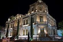
The city of Durango hosts a variety of museums including Museo Regional de Durango (Regional Museum of Durango), Museo Arqueológico de Durango Ganot-Peschard (Ganot-Peschard Museum of Archaeology), Museo de Arte Moderno Guillermo Ceniceros (Guillermo Ceniceros Art Museum), Museo de Arte Contemporáneo Angel Zárraga (Angel Zagarra Museum of Contemporary Art), Museo Temático de Cine "Museo del Cine" (Thematic Film Museum),Museo de la Revolución en Durango (Museum of the Revolution in Durango), Mueseo de Arte Sacro (Museum of Sacred Art) and a museum designed especially for children: El Bebeleche-Museo Interactivo de Durango (Bebeleche-Interactive Museum Durango).
El Parque Guadiana
El Parque Guadiana (Guadiana Park), is considered an urban forest that provides environmental services to the city such as the carbon cycle, temperature control, and psychological benefits to those whom visit the park. Parque Guadiana is also the habitat for many fauna species, especially the avifauna species that are found within the park.
El Parque Guadiana also offers kid-friendly infrastructure where children can play, a specialized trail for runners and walkers, fountains, an Olympic pool, and a town hall that was inaugurated in 1960. It also has a small train that goes around the Lago de los Patos "lake of the ducks", and until recently, a recreational bicycle path, ( it currently is being remodeled) in a wooded area that serves as a source of cool air to cyclists.
Media
The city has various local radio and television stations. Los 40 Principales Durango, La Tremenda, and Radio X are a few of the numerous local radio stations on air.
The following television stations operate locally in Durango: Channel 2: XHDRG-TV - Azteca, Durango XH Durango Channel 5: XHDI-TV - Televisa, Durango, Channel 7: XHDB-TV - Azteca, Durango, Channel 10: XHA-TV - Televisa, Durango, and Channel 12: XHND-TV - Televisora de Durango, Durango.
Retail markets
The city of Durango has numerous shops and boutiques that offer a variety products and goods. The city houses stand-alone supermarkets from chains including Soriana, Casa Ley, Wal-Mart, Sam's Club, Gigante and Oxxo.
Durango’s main and first official shopping mall is Paseo Durango with anchor stores such as Liverpool, Suburbia and eateries such as Applebee's, Subway, Italian Coffee Company, and Musashi. Paseo Durango also includes a movie theatre, and offers banking services, and various recreational activities.
The main market of the city is the eclectic Mercado de Abastos Francisco Villa located on the Southern-Central portion of the city which houses candy shops, Mesoamerican pottery, jewelry, haberdasheries, and it is the city's largest supplier of whole-sale produce, dairy, and meats.
Mercado Gomez Palacio is the oldest market in the city, which dates back to over 200 years and continues to sell the typical green produce as well as candles, typical clothing, sombreros, keys, hardware, flowers, jewelry, and bicycle-repair-services.[13]
Business
According the World Bank for doing business, Durango, Mexico is ranked 7 out of 32 cities in Mexico at ease of doing business. The ranking is based on four different categories, starting a business, dealing with construction permits, registration of a property, and enforcing contracts. According to these categories, Durango is ranked 23 in starting a business, 5 in dealing with construction permits, 15 in registration of the property and 8 in enforcing contracts.[14]
Sports
Unlike many cities in Mexico, soccer isn't the most popular sport in Durango. The city has a Second Division team named Alacranes de Durango (Durango Scorpions)
Probably, in Durango the most watched sport is Basketball, the city is the home of the Basketball team Durango Lumberjacks, (in Spanish Leñadores de Durango) who play in the Auditorio del Pueblo Gym.
Another popular sport in Durango is Baseball and softball, the city has a minor league team named los Alacranes de Beisbol (English; Durango Baseball Scorpions), having rivalry with the Dorados de Chihuahua and a semi-professional Softball team
American Football is one of the most appreciated sports in Durango. They have a semi-professional team named Centuriones de Durango playing for the AFAS Master League and a college football team, the ITD Burros Blancos, playing for the northerner conference of the ONEFA.
Other popular sports in the city are Bullfighting and Wrestling.
Demographics
According to the 2005 census, there were 526,629 people in the city and the surrounding communities of the municipality; INEGI projects a population of 631,712 by the 2010 census. The ethnic composition of the city is 51% European, 45% mestizo, 4% Arabs & East Asians, and less than 1% Indigenous.
Two-thirds of the city's residents live in single-family homes and 25% in apartment buildings; 9% live in sub-standard housing. Measured in terms of income, the city's poverty rate was 10.9% in 2003 and, including the municipality, 20.6%.[15] Other studies estimate that 200,000 in the metropolitan Durango area live in poverty.
The majority of Duranguenses, like many Northern Mexicans, have European origins, with most of them being criollos.
During the late 19th and early 20th centuries, there were small immigration waves to Northern and Central Mexico from Europe and the Middle East, many of which reached Durango. Most immigrants to the city arrived from Spain (mainly from the Basque Country, Galicia, and Asturias) and Germany (mainly Volga Germans) but also from Ireland, France, Italy, Switzerland, the Netherlands, and Sweden. There were also immigration waves from Eastern Europe, (mainly Russians and Poles) and from the Balkans (especially from Macedonia and Montenegro). Romanians, and Ukrainians arrived during the 1990s and most of them reside in immigrant ghettos in the inner city. There are roughly 7,000 Plautdietsch-speaking Mennonites living in the municipality of Durango. Durango also has recent retiree communities from Australia, the United States and South Africa.
Many post-colonial Spanish immigrants were from Galicia, and Spaniards are still generically referred to in Mexico as gallegos (Galicians). Galician language, cuisine and culture had a major presence in the city for most of the 20th century. In recent years, descendants of Galician immigrants have led a mini-boom in Celtic music.
The Armenian, Lebanese and Syrian/Arabs communities have had a significant presence in commerce and civic life since the beginning of the 20th century. Asians represent smaller communities and number about 1-2% of the city's population; most of them are Japanese while smaller numbers are Chinese and Koreans, the latter known in the city for owning family-style supermarkets.
Religion
The majority of the city, like the rest of Mexico is predominantly Roman Catholic. Protestants make-up less than 10% of the population, and most of them are Pentecostals, Charismatics, Jehovah's Witnesses and Mormons. Jews and Orthodox Christians represent smaller communities of about 1,000 each. Muslims in the state number about 5,000-7,000 with most of them living in Victoria de Durango.
Transportation
General Guadalupe Victoria International Airport is Durango's main airport.
There are several bus lines available. These include Omnibus de Mexico, Mexico Omnibus Plus, Tourists Luxury, Executive Senda AVE, North Transport, Transport North Premier, Futura, Transport Chihuahuenses, Mexico Interstate Bus (ELITE). Along with local lines, these are located at the city's bus terminal, General Domingo Arrieta. Within the city, taxicabs are available. Durango is one of the cities with the lowest taxi rates in the country.
The Baluarte Bridge (El Puente Baluarte) is a cable-stayed bridge that was inaugurated in January 2012.[16] It is located over the border between the states of Sinaloa and Durango, which is part of the new highway that will connect Mazatlan to Durango, replacing the old Mexican Federal Highway 40, a notoriously dangerous winding road known as the Devil's Backbone. which was the only road connecting these two states.[16] The new highway reduces travel times between Mazatlan and Durango by 6 hours.[16] It has a length of 1,124 m (3,688 ft), and a cable-stayed span of 520 m (1,710 ft). With a height of up to 390 m (1,280 ft) above the valley, the Baluarte Bridge is the highest cable stayed bridge in the world.[16] Construction started on 21 February 2008,[17] and the bridge was inaugurated in January 2012.
Education
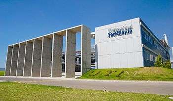
The municipality has adequate facilities to provide preschool, elementary, middle, and upper secondary, undergraduate and graduate education. The higher education institutions within the city are:
- Universidad Autónoma de Durango
- Universidad TecMilenio (TecMilenio University Durango Campus)
- Universidad España de Durango
- Universidad Del Valle de Guadiana
- Universidad Juarez del Estado de Durango
- Universidad José Vasconcelos
- Universidad Autónoma de Guadalajara
- Instituto Universitario Anglo Español
- Instituto Alejandría
- Instituto Tecnológico Forestal
- Instituto Tecnológico de Durango
- Centro Pedagógico de Durango, A.C.
- Centro Universitario Promedac
- Escuela de Odontología
- Escuela de Ciencias Químicas
- Escuela Superior de Música
- Facultad de Medicina
- Facultad de Medicina, Veterinaria y Zootecnia
- Facultad de Enfermería y Obstetricia
- Facultad de Contaduría y Administración
- Facultad de Derecho
The municipality also offers CONALEP, a technical institution. The city also houses numerous foreign and international educational institutions for the children of immigrants, including:
- Alianza Francesa de Durango
- Colegio Alemán Alexander von Humboldt
- American School of Durango
- Assured English Academy
- Academia Griega de Durango- Ελληνική Ακαδημία
- Liceo de Rusia-Русский лицей
Notable duranguenses
- Francisco Castillo Nájera
- Dolores del Rio
- René Elizondo Jr.
- Marlene Favela
- Ramón Novarro
- Andrea Palma (actress)
- The Revueltas family: José Revueltas, Rosaura Revueltas, Silvestre Revueltas, Fermín Revueltas Sánchez
- Guadalupe Victoria
- Pancho Villa
- Enrique Cruz or "El Carnicero" Student and recognized Ping Pong player
References
- ↑ "Información Nacional, por Entidad Federativa y Municipios". Instituto Nacional de Estadística y Geografía. Retrieved February 2, 2013.
- 1 2 "Durango". Catálogo de Localidades. Secretaría de Desarrollo Social (SEDESOL). Retrieved 23 April 2014.
- ↑ "History of Victoria de Durango". Retrieved 20 March 2010.
- ↑ Peel, M. C.; Finlayson B. L.; McMahon, T. A. (2007). "Updated world map of the Köppen–Geiger climate classification" (PDF). Hydrol. Earth Syst. Sci. 11: 1633–1644. doi:10.5194/hess-11-1633-2007. ISSN 1027-5606.
- 1 2 3 4 5 6 7 "Estado de Durango–Estacion: Durango (DGE)". NORMALES CLIMATOLÓGICAS 1951–2010 (in Spanish). Servicio Meteorológico Nacional. 2012. Retrieved January 5, 2013.
- 1 2 3 4 "Normales climatológicas para Durango, DGO." (in Spanish). Colegio de Postgraduados. Retrieved January 5, 2013.
- 1 2 3 "The North American Monsoon" (PDF). National Oceanic and Atmospheric Administration. Retrieved January 29, 2013.
- ↑ "Extreme Temperatures and Precipitation for Durango 1941-2000" (in Spanish). Servicio Meteorológico Nacional. Retrieved January 21, 2013.
- ↑ "NORMALES CLIMATOLÓGICAS 1981–2000" (PDF) (in Spanish). Servicio Meteorológico Nacional. Retrieved 3 May 2015.
- ↑ "Station 76423 Durango, DGO.". Global station data 1961–1990—Sunshine Duration. Deutscher Wetterdienst. Retrieved 3 May 2015.
- ↑ "FENADU - Feria Nacional Durango 2016". www.ferianacionaldurango.gob.mx. Retrieved 2016-11-14.
- ↑ "Ubicacion - Visita Durango". www.visitadurango.mx. Retrieved 2016-11-14.
- ↑ "Mercados en Durango, sobreviven de milagro.
http://www.oem.com.mx/esto/notas/n501991.htm". line feed character in
|title=at position 44 (help); External link in|title=(help); - ↑ "Doing Business in Durango, Mexico - Subnational Doing Business - World Bank Group". www.doingbusiness.org. Retrieved 2016-11-14.
- ↑ "Crece la pobreza por el centralismo. http://www.elsiglodedurango.com.mx/noticia/13107.crece-la-pobreza-por-el-centralismo.siglo". External link in
|title=(help); - 1 2 3 4 "Mexico inaugurates world's highest cable-stayed bridge". BBC. January 5, 2012. Retrieved February 9, 2013.
- ↑ "Da Calderón banderazo de inicio del puente Baluarte". Elsiglodetorreon.com.mx. 2008-02-22. Retrieved 2012-06-06.
Notes
- ↑ Station ID for Durango, DGO. is 76423 Use this station ID to locate the sunshine duration
External links
- Gobierno Municipal de Durango Official website
- Official Site of the State Government of Durango
- Film Commission Durango
-
 Durango (Durango) travel guide from Wikivoyage
 - Map of the touristic points of interest in Durango
