Drachselsried
| Drachselsried | ||
|---|---|---|
| ||
 Drachselsried | ||
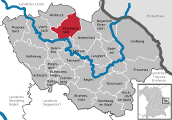
Location of Drachselsried within Regen district  | ||
| Coordinates: 49°6′N 13°1′E / 49.100°N 13.017°ECoordinates: 49°6′N 13°1′E / 49.100°N 13.017°E | ||
| Country | Germany | |
| State | Bavaria | |
| Admin. region | Niederbayern | |
| District | Regen | |
| Government | ||
| • Mayor | Johann Weininger (CSU) | |
| Area | ||
| • Total | 41.73 km2 (16.11 sq mi) | |
| Population (2015-12-31)[1] | ||
| • Total | 2,428 | |
| • Density | 58/km2 (150/sq mi) | |
| Time zone | CET/CEST (UTC+1/+2) | |
| Postal codes | 94256 | |
| Dialling codes | 09945 | |
| Vehicle registration | REG | |
| Website | www.drachselsried.de | |
Drachselsried is a municipality in the district of Regen, in Bavaria, Germany. Drachselsried is in the Zeller Valley (German: Zellertal), and is part of the Glass Road (Glasstrasse) The area is part of the Bavarian Forest National Park. The village is a small, highly organised, friendly place to live. Bayern Eins, the German radio station, gave some history details of the village, which was first noted in 1184. More information from an Englishman living in the village.
References
- ↑ "Fortschreibung des Bevölkerungsstandes". Bayerisches Landesamt für Statistik und Datenverarbeitung (in German). June 2016.
This article is issued from Wikipedia - version of the 6/21/2015. The text is available under the Creative Commons Attribution/Share Alike but additional terms may apply for the media files.
