Dohuk Dam
| Dohuk Dam | |
|---|---|
 Dohuk Dam | |
 Location of Dohuk Dam in Iraq | |
| Country | Iraq |
| Location | Dohuk |
| Coordinates | 36°52′33″N 43°00′13″E / 36.87583°N 43.00361°ECoordinates: 36°52′33″N 43°00′13″E / 36.87583°N 43.00361°E |
| Status | Operational |
| Opening date | 1988 |
| Dam and spillways | |
| Type of dam | Embankment, earth-fill |
| Impounds | Dohuk River |
| Height | 60 m (197 ft) |
| Length | 600 m (1,969 ft) |
| Spillway type | Bell-mouth |
| Spillway capacity | 81 m3/s (2,860 cu ft/s) |
| Reservoir | |
| Total capacity | 52,000,000 m3 (42,157 acre·ft) |
| Max. length | 4 km (2 mi) |
| Max. width | 1.7 km (1 mi) |
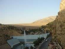
The Dohuk Dam is an earth-fill embankment dam on the Dohuk River just north of Dohuk in Dahuk Governorate, Iraq. The dam was completed in 1988 with the primary purpose of providing water for irrigation. It is 60 m (197 ft) tall and can withhold 52,000,000 m3 (42,157 acre·ft) of water. The dam has a bell-mouth spillway with a maximum discharge of 81 m3/s (2,860 cu ft/s).[1]
See also
References
- ↑ "Iraqi Dam Assessments" (PDF). Iraq: United States Army, Corps of Engineers. 6 June 2003. Retrieved 27 February 2012.
| Wikimedia Commons has media related to Duhok Dam. |
This article is issued from Wikipedia - version of the 9/15/2015. The text is available under the Creative Commons Attribution/Share Alike but additional terms may apply for the media files.