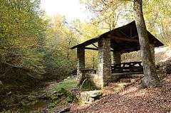
Collier Springs Picnic Area
|
Collier Springs Shelter | |
 | |
  | |
| Nearest city | Norman, Arkansas |
|---|---|
| Coordinates | 34°29′1″N 93°35′33″W / 34.48361°N 93.59250°WCoordinates: 34°29′1″N 93°35′33″W / 34.48361°N 93.59250°W |
| Area | less than one acre |
| Built | 1939 |
| Architectural style | Rustic |
| MPS | Facilities Constructed by the CCC in Arkansas MPS |
| NRHP Reference # | 93001083[1] |
| Added to NRHP | October 20, 1993 |
The Collier Springs Picnic Area is located on Forest Road 177 in Ouachita National Forest, northeast of Norman, Arkansas. The picnic area is notable for the presence of the Collier Springs Shelter, which was built by crews of the Civilian Conservation Corps in 1939. It is a rectangular open-air stone structure, with stone columns topped by hewn log beams that support the gabled roof. The shelter also acts as a protective cover for the eponymous spring, which is fed via a pipe to the nearby creek.[2] Facilities at the picnic area also include a vault toilet.
See also
References
- ↑ National Park Service (2010-07-09). "National Register Information System". National Register of Historic Places. National Park Service.
- ↑ "NRHP nomination for Collier Springs Shelter" (PDF). Arkansas Preservation. Retrieved 2015-10-05.
This article is issued from Wikipedia - version of the 12/2/2016. The text is available under the Creative Commons Attribution/Share Alike but additional terms may apply for the media files.