City of Greater Dandenong
| City of Greater Dandenong Victoria | |||||||||||||
|---|---|---|---|---|---|---|---|---|---|---|---|---|---|
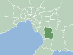
 Map of Melbourne showing City of Greater Dandenong | |||||||||||||
| Population | 152,739 (2015 est)[1] | ||||||||||||
| • Density | 1,180.18/km2 (3,056.65/sq mi) | ||||||||||||
| Established | 1994 | ||||||||||||
| Area | 129.42 km2 (50.0 sq mi) | ||||||||||||
| Mayor | Meng Heang Tak | ||||||||||||
| Council seat | Dandenong | ||||||||||||
| State electorate(s) | |||||||||||||
| Federal Division(s) | |||||||||||||
 | |||||||||||||
| Website | City of Greater Dandenong | ||||||||||||
| |||||||||||||
The City of Greater Dandenong is a local government area in Victoria, Australia in the southeastern suburbs of Melbourne. It has an area of just under 130 square kilometres (50 sq mi) and approximately 146,000 residents in 2014.
It was formed in 1994 by the merger of parts of the former City of Dandenong and City of Springvale.
Wards and councillors
| Greater Dandenong City Council | |
|---|---|
| Type | |
| Type |
Council of the City of Greater Dandenong |
| Structure | |
 | |
Council political groups | |
The Victorian Electoral Commission (VEC) completed a review of Greater Dandenong’s electoral system in May 2008. As a result, the City of Greater Dandenong is now divided into four wards: Lightwood (three councillors), Paperbark (three councillors), Red Gum (three councillors) and Silverleaf (two councillors).
- Red Gum Ward – The largest ward geographically, taking in the suburbs of Dandenong, Dandenong North (part), Dandenong South, Keysborough, Lyndhurst (part) and Bangholme
- Paperbark Ward – taking in the suburbs of Noble Park and Keysborough (part)
- Lightwood Ward – taking in the suburbs of Springvale, Springvale South and Noble Park (part)
- Silverleaf Ward – taking in Noble Park North and a section of Dandenong North
| Ward | Councillor | Notes | |
|---|---|---|---|
| Lightwood | Youhorn Chea[2] | ||
| Sean O'Reilly[2] | |||
| Loi Truong[2] | |||
| Paperbark | Roz Blades[3] | ||
| Peter Brown[3] | |||
| Meng Heang Tak[3] | |||
| Red Gum | Matthew Kirwan[4] | ||
| Angela Long[5] | |||
| Jim Memeti[5] | |||
| Silverleaf | Maria Sampey | ||
| John Kelly[lower-alpha 1] | |||
History
In 1994, the Jeff Kennett government restructured local government in Victoria. His reforms dissolved 210 councils and created 78 new councils through amalgamations. As part of the reforms City of Springvale and City of Dandenong were merged to create City of Greater Dandenong.
Clare O'Neil became the youngest female mayor in Australian history when she served as Mayor of Greater Dandenong from 2003 to 2004.
Places of interest
Suburbs and towns
- Bangholme
- Dandenong
- Dandenong North
- Dandenong South
- Keysborough
- Parts of Lyndhurst
- Noble Park
- Noble Park North
- Springvale
- Springvale South
Sport
Dandenong Rangers play home games at the Dandenong Basketball Stadium and compete in the WNBL. Two championships have been won in the 2003-04 and 2004-05 seasons and again in 2005/2006 the team reached the Grand Final only to lose to the Canberra Capitals.
Dandenong Thunder compete in the Victorian Premier League, playing at George Andrews Reserve.
The Greater Dandenong Warriors Hockey Club is based at the Bill Toon Playing fields on Cleeland Road, Dandenong North. The club currently fields 5 Men's teams, 2 Women's teams, 6 Junior teams and 3 Veteran's team.
Community groups
Greater Dandenong has many active community groups.
Service clubs include the Lions Club of Greater Dandenong, the Lions Club of Dandenong, the Lions Club of Dandenong (Supper), the Rotary Club of Dandenong, the Rotary Club of Noble Park and the Rotary Club of Springvale.
Schools
Due to this connection these schools in Greater Dandenong have established relationships with schools in Xuzhou:
- Wallarano Primary School & Minzulu
- Coomoora Secondary College & Xuzhou No. 3
- Springvale Primary School & Xuzhou Arts School
- Maralinga Primary School & Jinshinqaun
- Noble Park English Language School & Xingi Middle School
- Springvale Secondary College & Xuzhou No.1 Middle School
Notes
References
- ↑ "3218.0 – Regional Population Growth, Australia, 2014–15". Australian Bureau of Statistics. Retrieved 29 September 2016.
- 1 2 3 http://dandenong.starcommunity.com.au/uncategorized/2012-10-01/greater-dandenong-council-elections-lightwood-ward/
- 1 2 3 http://dandenong.starcommunity.com.au/uncategorized/2012-10-01/greater-dandenong-council-elections-paperbark-ward/
- ↑ http://greens.org.au/vic/representatives
- 1 2 http://dandenong.starcommunity.com.au/uncategorized/2012-10-01/greater-dandenong-council-elections-red-gum-ward/
- ↑ http://dandenong.starcommunity.com.au/uncategorized/2012-10-01/greater-dandenong-council-elections-silverleaf-ward/
External links
- Official website
- Metlink local public transport map
- Link to Land Victoria interactive maps
- Local Government & Municipal Knowledge Base
- Victorian Electoral Commission – Greater Dandenong City Council profile
Coordinates: 38°00′S 145°11′E / 38.000°S 145.183°E