Chilkigarh
| Chilkigarh | |
|---|---|
| Village | |
 Chilkigarh  Chilkigarh Location in West Bengal, India | |
| Coordinates: 22°27′03.6″N 86°52′44.4″E / 22.451000°N 86.879000°ECoordinates: 22°27′03.6″N 86°52′44.4″E / 22.451000°N 86.879000°E | |
| Country |
|
| State | West Bengal |
| District | Paschim Medinipur |
| Population (2011) | |
| • Total | 1,553 |
| Languages | |
| • Official | Bengali, English |
| Time zone | IST (UTC+5:30) |
| PIN | 721503 (Chilkigarh) |
| Telephone/STD code | 03221 |
| Lok Sabha constituency | Jhargram |
| Vidhan Sabha constituency | Binpur |
| Website |
paschimmedinipur |
Chilkigarh is a village in Jamboni CD Block in Jhargram subdivision of Paschim Medinipur district in the state of West Bengal, India.
Geography
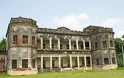
Chilkigarh Rajbari
Chilkigarh is 12 km from Jhargram. Chilkigarh Rajbari and Kanak Durga temple attract tourists The Dulung River flows between the two. [1]
Demographics
As per 2011 Census of India Chilkigarh had a total population of 1,553 of which 794 (51%) were males and 759 (49%) were females. Population below 6 years was 178. The total number of literates in Chilkigarh was 980 (63.10% of the population over 6 years).[2]
Transport
SH 9 from Durgapur (in Bardhaman district) to Nayagram (in Paschim Medinipur) passes through Chilkigarh.[3]
External links
![]() Jhargram travel guide from Wikivoyage
Jhargram travel guide from Wikivoyage
References
- ↑ "Legacy of Midnapore". Chilkigarh Raj Place and Kanak Durga Temple. midnapore.in. Retrieved 2 November 2016.
- ↑ "2011 Census – Primary Census Abstract Data Tables". West Bengal – District-wise. Registrar General and Census Commissioner, India. Retrieved 27 October 2016.
- ↑ "List of State Highways in West Bengal". West Bengal Traffic Police. Retrieved 23 August 2016.
Cities, towns and locations in Paschim Medinipur District | |||||||||||||||
|---|---|---|---|---|---|---|---|---|---|---|---|---|---|---|---|
| Cities, municipal and census towns |
| ||||||||||||||
| Locations other than cities and towns |
| ||||||||||||||
| Related topics |
| ||||||||||||||
This article is issued from Wikipedia - version of the 11/2/2016. The text is available under the Creative Commons Attribution/Share Alike but additional terms may apply for the media files.