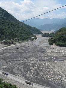
Chenyoulan River
| Chenyoulan River 陳有蘭溪 | |
|---|---|
 | |
 Mugua River in Taiwan | |
| Country | Taiwan |
| Basin | |
| Main source | Mount Yushan |
| River mouth |
Zhuoshui River at Shuili, Nantou 23°46′44″N 120°51′58″E / 23.779°N 120.866°ECoordinates: 23°46′44″N 120°51′58″E / 23.779°N 120.866°E |
| River system | Zhuoshui River basin |
| Basin size | 448 km2 (173 sq mi) |
| Physical characteristics | |
| Length | 42.4 km (26.3 mi) |
| Discharge |
|
The Chenyoulan River or Chenyulan River (Chinese: 陳有蘭溪; Pe̍h-ōe-jī: Tân-iú-lân-khe) is a river in Nantou County, Taiwan.[1] It is a tributary of the Zhuoshui River. Villages in the water shed include Dongpu and Fengqui. Its tributary streams are Junkeng, Shibachong, Shalixian, Heshe and Neimaopu Streams. The catchment area is 450 m2 and its length is 42.4 km. The average slope is 5%. The upper reaches drain the north slopes of Yushan up to 3910 metres elevation.[2] he path of the river has been set by the Chenyulan fault.
References
- ↑ "GeoNames Search". Geographic Names Database. National Geospatial-Intelligence Agency, USA. Retrieved 31 May 2016.
- ↑ Ping-Sien Lin; Ji-Yuan Lin; Shang-Yuh Lin; Jiunnren Lai (2006). "Hazard Assessment of Debris Flows by Statistical Analysis and GIS in Central Taiwan" (PDF). International Journal of Applied Science and Engineering. 4 (2): 165–287.
This article is issued from Wikipedia - version of the 6/25/2016. The text is available under the Creative Commons Attribution/Share Alike but additional terms may apply for the media files.