Chammliberg
| Chammliberg | |
|---|---|
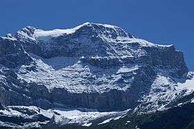 The north-west face | |
| Highest point | |
| Elevation | 3,215 m (10,548 ft) |
| Prominence | 194 m (636 ft) [1] |
| Parent peak | Clariden |
| Coordinates | 46°50′12″N 08°50′41.5″E / 46.83667°N 8.844861°ECoordinates: 46°50′12″N 08°50′41.5″E / 46.83667°N 8.844861°E |
| Geography | |
 Chammliberg Location in Switzerland | |
| Location | Uri, Switzerland |
| Parent range | Glarus Alps |
The Chammliberg is a mountain of the Glarus Alps, located south of the Klausen Pass in the canton of Uri. While the south side of the mountain is covered by the large Hüfi Glacier, the north-west side consists of an 800 metre high face.
References
External links
| Wikimedia Commons has media related to Chammliberg. |
This article is issued from Wikipedia - version of the 5/8/2016. The text is available under the Creative Commons Attribution/Share Alike but additional terms may apply for the media files.