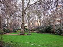
Bryanston Square


Bryanston Square is a long rectangular terraced square in Marylebone, Westminster, London, England, originally of 50 sequential numbers however some of which have been combined such as the Swiss Embassy in London.
Amenities and neighbours
Wyndham Place
St Mary's, Bryanston Square in the Church of England is beyond its northern end along its short (thus in this context and under its building plan which was constructed considered) continuation: Wyndham Place. The church is listed in the top category and was designed in 1821 by Robert Smirke.
Great Cumberland Street
A similar distance to the south along its southern narrowed continuation, broadening in the middle into a small crescent is Western Marble Arch Synagogue. The projection is Great Cumberland Street which is approximately one third of the width as measured from building to building. The thoroughfare culminates with the Marble Arch before which the street is flanked by Cumberland Court and the Cumberland Hotel which incorporates the tube station. Its uses vary between residential use and hotel use.
Architectural context and features
Beyond half of its mews is Montagu Square to the east and beyond a few similarly ornate streets is the Paddington and Marylebone-dividing Edgware Road. Bryanston Square is of approximately equal area to Portman Square. It has wide roads, many buildings of which have listed status, and a private tree-lined garden. Wetherby Preparatory School occupies part of the block from the south west corner. Listed are:
Colour and height and neat façades make the square geometric and yet differentiated. Slightly varied yellowy-brown brickwork from address to address (historically referred to as 'yellow bricks') is accompanied in by differing mansard roofs, mostly of grey slate — a minority is of red-brown bricks. Decorative black balconies above the first level are accompanied by a white chamfered band course at the penultimate level before the mansard. At the divide of the mansards or parapet roofs with roof gardens is a longer such course forming a more pronounced white band course which is a cornice. All of the casements are tall white, multi-pane sash windows of uniform height and distribution.[1][2][3]
In the south is the William Pitt Byrne Memorial Fountain, erected in 1862, a Grade II (initial category) listed monument under the statutory protection scheme,[4] as is an ornamental water pump at the opposite end.[5] Two other buildings form the bulk of the equally interrupted southern façade, listed, 63 and 68 George Street.
Ambassadorial presence
- Swiss Embassy in London at 1A (formerly 16 to 22)
History
Named after its founder Henry William Portman's home village of Bryanston in Dorset, it was built as part of the Portman Estate between 1810 and 1815, along with Montagu Square beyond a mews to the east.
Notable people
- George Shaw-Lefevre, 1st Baron Eversley (1831-1928) minister of state and co-founder of the Commons Preservation Society to protect among others Hampstead Heath and Epping Forest[6]
- Osmond Barnes (1834–1930), Indian Army officer, was born at 7 Bryanston Square, on 23 December 1834. As Chief Herald of India he proclaimed Queen Victoria Empress of India at Delhi in 1877.
- Emma Elizabeth Thoyts (1860–1949) historian was born in a house on the Square.
- Abe Bailey (1864-1940) South African politician, businessman and sportsman lived at 38 Bryanston Square. The talks which led to David Lloyd George succeeding H. H. Asquith as Prime Minister of the United Kingdom took place in Bailey's house in December 1916.[7] Major-Gen H Lyndoch Gardiner (1820–1897) Queen's Equerry lived at No 31 Bryanston Square.
- Sir Reginald Hanson, 1st Baronet, one of the two Members of Parliament for The City of London for the nine years to 1900. Bryanston Square is the territorial designation of his title which became extinct in 1996.
- 1st-3rd Lords Farrer. This title was given to a senior civil servant who was a statistician in the mid 19th century.
- Wallis Simpson, the future wife of Edward VIII lived at Bryanston Square just before his abdication in December 1936.
- William Dodge James died at his home at 28 Bryanston Square.
References
- 1 2 Historic England. "Details from listed building database (1066353)". National Heritage List for England. Retrieved 26 March 2015.
- 1 2 Historic England. "Details from listed building database (1066354)". National Heritage List for England. Retrieved 26 March 2015.
- 1 2 Historic England. "Details from listed building database (1066355)". National Heritage List for England. Retrieved 26 March 2015.
- ↑ "William Pitt Byrne Memorial Fountain, Paddington". British Listed Buildings Online. Retrieved 2011-03-01.
- ↑ Historic England. "Details from listed building database (1066357)". National Heritage List for England. Retrieved 26 March 2015.
- ↑ "Shaw-Lefevre, George John (SHW849GJ)". A Cambridge Alumni Database. University of Cambridge.
- ↑ Maryna Fraser, ‘Bailey, Sir Abraham , first baronet (1864–1940)’, Oxford Dictionary of National Biography, Oxford University Press, Sept 2004; online edn, May 2006 accessed 25 Aug 2008
External links
Coordinates: 51°31′03″N 0°09′39″W / 51.51750°N 0.16083°W