Brandoa
| Brandoa | |||
|---|---|---|---|
| Municipality | |||
| |||
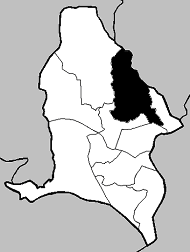 Location in Portugal | |||
| Coordinates: 38°46′N 9°13′W / 38.767°N 9.217°WCoordinates: 38°46′N 9°13′W / 38.767°N 9.217°W | |||
| Country |
| ||
| Region | Lisbon | ||
| District/A.R. | Lisbon | ||
| Area | |||
| • Total | 2.39 km2 (0.92 sq mi) | ||
| Population | |||
| • Total | 15,647 | ||
| • Density | 6,546.9/km2 (16,956/sq mi) | ||
| Website | https://web.archive.org/web/20070701153554/http://www.jf-brandoa.pt:80/ | ||


Brandoa (Portuguese pronunciation: [bɾɐ̃ˈdoɐ]) is a former civil parish, located in the municipality of Amadora, Portugal. In 2013, the parish merged into the new parish Encosta do Sol. It is situated in the outskirts of Lisbon, with 2,39 km² of area and 15,647 inhabitants (2001).
This article is issued from Wikipedia - version of the 11/7/2016. The text is available under the Creative Commons Attribution/Share Alike but additional terms may apply for the media files.