Botany Parish, Cumberland
| Botany New South Wales | |||||||||||||
|---|---|---|---|---|---|---|---|---|---|---|---|---|---|
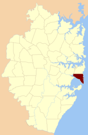
 Location of the parish within Cumberland | |||||||||||||
| Coordinates | Coordinates: 33°56′54″S 151°14′04″E / 33.94833°S 151.23444°E | ||||||||||||
| Established | 1835 | ||||||||||||
| LGA(s) | Bayside Council | ||||||||||||
| County | Cumberland | ||||||||||||
| Hundred (former) | Sydney | ||||||||||||
| |||||||||||||
Botany Parish, Cumberland is one of the 57 parishes of Cumberland County, New South Wales, a cadastral unit for use on land titles. It contains the area to the north of Botany Bay and to the east of part of Cooks River. It includes the suburbs of La Perouse, Hillsdale, Banksmeadow and Maroubra. It also includes Sydney Airport.
References
- "Botany Parish". Geographical Names Register (GNR) of NSW. Geographical Names Board of New South Wales.
This article is issued from Wikipedia - version of the 9/22/2016. The text is available under the Creative Commons Attribution/Share Alike but additional terms may apply for the media files.