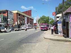
Borella
| Borella බොරැල්ල பொறளை | |
|---|---|
| Suburb | |
|
Borella | |
 Borella | |
| Coordinates: 6°54′53″N 79°52′40″E / 6.91472°N 79.87778°ECoordinates: 6°54′53″N 79°52′40″E / 6.91472°N 79.87778°E | |
| Country | Sri Lanka |
| Province | Western Province |
| District | Colombo District |
| Time zone | Sri Lanka Standard Time Zone (UTC+5:30) |
| Postal Code | 00800 [1] |
Borella is the largest suburb in Colombo, Sri Lanka represented by divisional code 8.
Demographic
Borella is a multi-religious and multi-ethnic area. The major ethnic communities in Borella are Sinhalese and Tamils. There are also various other minorities such as Burghers, Sri Lankan Moors and others. Religions include Buddhism, Hinduism, Islam, Christianity and various other religions and beliefs to a lesser extent.
Sports venues
- Paikiasothy Saravanamuttu Stadium also known as P. Sara Oval and Tamil Union Cricket and Athletic Club.
- Royal Colombo Golf Club (also known as Ridgeway Links). Founded in 1879 it is the oldest in the country and one of the oldest in Asia.
Schools
- Sunrise International Preschool
- Wesley College
- Bandaranayake Vidyalaya
- Carey College, Borella
- Devi Balika Vidyalaya
- C. W. W. Kannangara Vidyalaya
- Susamaya Wardana Maha Vidyalaya
- Rathnawali Balika Maha Vidyalaya
- D.S.Senanayaka College
- Colombo Overseas School
- Gateway International School
- Oxford Overseas School
Cemetery
.jpg)
The General Cemetery (Kanatte) is located in Borella. It is the main National Burial Ground and Crematorium for the City of Colombo. It is located at the intersection of Narahenpita Road (Elvitigala Mawatha), Bullers Road (Bauddhaloka Mawatha), and Baseline Road (D S Senanayake Mawtha) at a large traffic circle. The cemetery was established in 1840 and is a very popular place of burial for all nationalities. A section is dedicated for those who were lost during the I and II World wars.
 |
Maradana | Dematagoda | Welikada |  |
| Cinnamon Gardens | |
Rajagiriya | ||
| ||||
| | ||||
| Narahenpita | Narahenpita | Nawala |
