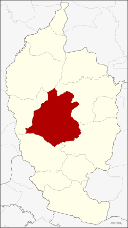
Borabue District
| Borabue บรบือ | |
|---|---|
| Amphoe | |
 Amphoe location in Maha Sarakham Province | |
| Coordinates: 16°2′18″N 103°7′9″E / 16.03833°N 103.11917°ECoordinates: 16°2′18″N 103°7′9″E / 16.03833°N 103.11917°E | |
| Country | Thailand |
| Province | Maha Sarakham |
| Seat | Borabue |
| Area | |
| • Total | 681.6 km2 (263.2 sq mi) |
| Population (2005) | |
| • Total | 108,256 |
| • Density | 158.8/km2 (411/sq mi) |
| Time zone | ICT (UTC+7) |
| Postal code | 44130 |
| Geocode | 4406 |
Borabue (Thai: บรบือ) is a district (amphoe) in the central part of Maha Sarakham Province, northeastern Thailand.
Geography
Neighboring districts are (from the north clockwise) Kosum Phisai, Mueang Maha Sarakham, Wapi Pathum, Na Chueak, and Kut Rang.
History
In 1897 the district was established, then named Patchim Sarakham (ปจิมสารคาม). 1913 it was renamed to Thakhon Yang (ท่าขรยาง).[1] In 1914 the governor of Maha Sarakham granted the new name Borabue (at first spelled บ่อระบือ, later shortened to บรบือ).[2]
Administration
The district is divided into 15 sub-districts (tambon), which are further subdivided into 203 villages (muban). Borabue is a sub-district municipality (thesaban tambon) which covers parts of tambon Borabue. There are a further 15 tambon administrative organizations (TAO).
| No. | Name | Thai name | Villages | Pop. | |
|---|---|---|---|---|---|
| 1. | Borabue | บรบือ | 16 | 14,026 | |
| 2. | Bo Yai | บ่อใหญ่ | 17 | 13,275 | |
| 4. | Wang Chai | วังไชย | 10 | 5,004 | |
| 5. | Nong Muang | หนองม่วง | 13 | 6,489 | |
| 6. | Kamphi | กำพี้ | 15 | 6,979 | |
| 7. | Non Rasi | โนนราษี | 13 | 7,299 | |
| 8. | Non Daeng | โนนแดง | 19 | 11,732 | |
| 10. | Nong Chik | หนองจิก | 20 | 9,319 | |
| 11. | Bua Mat | บัวมาศ | 9 | 3,580 | |
| 13. | Nong Khu Khat | หนองคูขาด | 16 | 6,369 | |
| 15. | Wang Mai | วังใหม่ | 10 | 4,836 | |
| 16. | Yang | ยาง | 15 | 4,010 | |
| 18. | Nong Sim | หนองสิม | 10 | 5,521 | |
| 19. | Nong Ko | หนองโก | 10 | 5,669 | |
| 20. | Don Ngua | ดอนงัว | 10 | 4,148 |
Missing numbers are tambon which now form Kut Rang District.
References
- ↑ แจ้งความกระทรวงมหาดไทย เรื่อง เปลี่ยนนามอำเภอ (PDF). Royal Gazette (in Thai). 30 (0 ง): 1619–1620. October 19, 1913.
- ↑ ประกาศกระทรวงมหาดไทย เรื่อง เปลี่ยนชื่ออำเภอ (PDF). Royal Gazette (in Thai). 34 (0 ก): 40–68. 1917-04-29.
External links
- amphoe.com (Thai)