Biglands

Coordinates: 54°52′01″N 3°09′40″W / 54.867°N 3.161°W
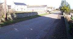
Biglands is a hamlet in Cumbria, England. It is located to the north of Gamelsby.[1] The first milefortlet is located here on the west end of Hadrian's Wall, and archaeological exploration in the area has revealed three periods of occupation in the second century, between 125-180/200.[2][3] A school was once located at Biglands, but it closed and was incorporated with Wiggonby school in 1959.[4]
See also
References
| Wikimedia Commons has media related to Biglands. |
- ↑ Maps (Map). Google Maps.
- ↑ Great Britain. Ministry of Public Building and Works; Great Britain. Dept. of the Environment (1 January 1976). Archaeological excavations. HMSO. ISBN 978-0-11-670781-9. Retrieved 9 July 2012.
- ↑ Christine Michal Mahany; Stephen Cracknell; M. S. Alabaster; Donald M. Bailey; Council for British Archaeology (1994). Roman Alcester: Southern extramural area : 1964-1966 excavations. Finds and discussion. Council for British Archaeology. p. 167. ISBN 978-1-872414-42-3. Retrieved 9 July 2012.
- ↑ Smith, Kenneth (1973). Cumbrian Villages. R. Hale. p. 90. ISBN 978-0-7091-4175-4. Retrieved 9 July 2012.
This article is issued from Wikipedia - version of the 10/10/2016. The text is available under the Creative Commons Attribution/Share Alike but additional terms may apply for the media files.