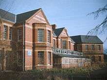
Barnsley Hall Hospital

Barnsley Hall Hospital was a psychiatric facility located in Bromsgrove, Worcestershire, on a 324-acre (131 ha) site purchased by the County Council in 1899. It opened in 1907, to relieve pressure on the county's only existing asylum, Powick Hospital near Malvern and to serve the northern part of the county. By 1929 it had reached its capacity of around 720 patients. Additional buildings increased its capacity to about 1,200, but it was heavily populated when it was used as a military hand emergency hospital during the two World Wars. The hospital closed in 1996 and most of the patients were settled into the community.
During its operation it had been known as Worcestershire Mental Hospital (1929 - 1947), Barnsley Hall Mental Hospital (1948), and Barnsley Hall Hospital for Nervous and Mental Diseases (1949 - 1966) and had been administered by several different district, regional, and county authorities. At the time of its closure, it was managed by Worcestershire county, providing a continuation of psychiatric care after the Powick Hospital closed in 1989.[1]
Originally reserved as an Area of Development Restraint following the closure of the hospital closure,[2] the land has been replaced by residential development as part of a drive to sell off NHS property in order to increase national housing stock in conjunction with a government plan to construct housing at affordable rents, while the sale would boost the NHS funds.[3] After closure, only the administration block, part of the original complex designed by architect George Thomas Hine, an airing court shelter, and the porter's lodge, were retained.[4] Attempts to get Its landmark water tower listed failed and it was finally demolished in 2000.[5]
See also
References
- ↑ National Archives Retrieved 28 July 2009
- ↑ Bromsgrove Council Archived July 4, 2009, at the Wayback Machine. Retrieved 28 July 2009
- ↑ BBC News Retrieved 28 July 2009
- ↑ County Asylums Retrieved 28 July 2009
- ↑ British Water Tower Appreciation Society Retrieved 28 July 2009
Coordinates: 52°21′06″N 2°03′32″W / 52.351676°N 2.05888°W