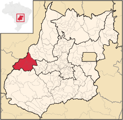
Microregion of Aragarças
| Aragarças | |
|---|---|
| Microregion | |
 Location in Goias state | |
| Country | Brazil |
| State | Goiás |
| Mesoregion | Noroeste Goiano |
| Municipalities | 7 |
| Area | |
| • Total | 11,091.90 km2 (4,282.61 sq mi) |
| Population (2007) | |
| • Total | 53,541 |
| • Density | 4.8/km2 (13/sq mi) |
The Aragarças Microregion is a geographical division in Goiás state, Brazil. It consists of 7 municipalities located around Aragarças in western Goiás.
Municipalities
The microregion consists of the following municipalities:[1]
| Name | Population | Area in km2 |
|---|---|---|
| Aragarças | 17,156 | 660 |
| Arenópolis | 3,495 | 3,495 |
| Baliza | 3,299 | 1,789 |
| Bom Jardim de Goiás | 8,372 | 1,557 |
| Diorama | 2,236 | 687 |
| Montes Claros de Goiás | 7,844 | 2,899 |
| Piranhas | 11,139 | 2,047 |
| Total | 53,541 | 11,092 |
The most populous municipality is Aragarças with 17,156 inhabitants and the least populous is Diorama with 2,236 inhabitants. The largest municipality in area is Montes Claros de Goiás with 2,909.4 km² and the smallest is Diorama with 689.6 km².
See also
References
- ↑ Instituto Brasileiro de Geografia e Estatística, territorial division.
Coordinates: 15°53′52″S 52°15′03″W / 15.89778°S 52.25083°W
This article is issued from Wikipedia - version of the 11/1/2016. The text is available under the Creative Commons Attribution/Share Alike but additional terms may apply for the media files.
