Antonaves
| Antonaves | ||
|---|---|---|
|
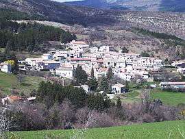
A view of the village in Antonaves | ||
| ||
 Antonaves | ||
|
Location within Provence-A.-C.d'A. region  Antonaves | ||
| Coordinates: 44°16′02″N 5°48′20″E / 44.2672°N 5.8056°ECoordinates: 44°16′02″N 5°48′20″E / 44.2672°N 5.8056°E | ||
| Country | France | |
| Region | Provence-Alpes-Côte d'Azur | |
| Department | Hautes-Alpes | |
| Arrondissement | Gap | |
| Canton | Ribiers | |
| Intercommunality | Ribiers Val de Méouge | |
| Government | ||
| • Mayor (2014–2020) | Isabelle Boiteux[1] | |
| Area1 | 8.03 km2 (3.10 sq mi) | |
| Population (2012)2 | 180 | |
| • Density | 22/km2 (58/sq mi) | |
| Time zone | CET (UTC+1) | |
| • Summer (DST) | CEST (UTC+2) | |
| INSEE/Postal code | 05005 / 05300 | |
| Elevation |
512–1,414 m (1,680–4,639 ft) (avg. 625 m or 2,051 ft) | |
|
1 French Land Register data, which excludes lakes, ponds, glaciers > 1 km² (0.386 sq mi or 247 acres) and river estuaries. 2 Population without double counting: residents of multiple communes (e.g., students and military personnel) only counted once. | ||

Antonaves is a former commune of the Hautes-Alpes department in southeastern France. On 1 January 2016, it was merged into the new commune Val Buëch-Méouge.[2] It is located at the confluence of the Méouge river (La Méouge) and the Le Buëch river, and is known as the gateway to the Gorges de la Méouge, a 4 km limestone gorge.
Population
| Historical population | ||
|---|---|---|
| Year | Pop. | ±% |
| 1962 | 60 | — |
| 1968 | 62 | +3.3% |
| 1975 | 70 | +12.9% |
| 1982 | 101 | +44.3% |
| 1990 | 126 | +24.8% |
| 1999 | 158 | +25.4% |
| 2008 | 179 | +13.3% |
| 2012 | 180 | +0.6% |
See also
References
- ↑ "List of mayors of the Hautes-Alpes department". Prefecture of Hautes-Alpes (in French). 3 June 2014. Archived from the original on 10 January 2015. Retrieved 20 March 2015.
- ↑ Arrêté préfectoral 27 August 2015 (French)
| Wikimedia Commons has media related to Antonaves. |
This article is issued from Wikipedia - version of the 10/15/2016. The text is available under the Creative Commons Attribution/Share Alike but additional terms may apply for the media files.