Annesley Woodhouse
| Annesley Woodhouse | |
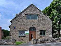
 The Library |
|
 Annesley Woodhouse |
|
| OS grid reference | SK4953 |
|---|---|
| District | Ashfield |
| Shire county | Nottinghamshire |
| Region | East Midlands |
| Country | England |
| Sovereign state | United Kingdom |
| Post town | Nottingham |
| Postcode district | NG17 |
| Dialling code | 01623 |
| Police | Nottinghamshire |
| Fire | Nottinghamshire |
| Ambulance | East Midlands |
| EU Parliament | East Midlands |
|
|
Coordinates: 53°04′N 1°16′W / 53.07°N 01.27°W
Annesley Woodhouse is a village in Nottinghamshire, England, located approximately 10 miles north of the City of Nottingham and 6 miles south of Mansfield, close to Junction 27 of the M1. With a current population of around 3.500,from the 2011 census being included in the civil parish of Annesley, it originated as a farming community and expanded in the 19th and 20th centuries as the mining industry locally was established and grew. In the postwar years and beyond, the village has grown rapidly and conjoined with neighbouring villages Nuncargate & Kirkby Woodhouse. All have now become an extension of their 'parent' town, Kirkby-in-Ashfield. With the demise of the mining industry in the 1990s Annesley Woodhouse is now largely a residential area with people travelling out of the village for education, employment and leisure.
A windmill was located near to Midfield Road (grid reference SK507542).
External links
![]() Media related to Annesley Woodhouse at Wikimedia Commons
Media related to Annesley Woodhouse at Wikimedia Commons