Üzümlü, Erdemli
| Üzümlü | |
|---|---|
| Village | |
 | |
 Üzümlü Location in Turkey | |
| Coordinates: 36°51′N 34°20′E / 36.850°N 34.333°ECoordinates: 36°51′N 34°20′E / 36.850°N 34.333°E | |
| Country |
|
| Province | Mersin Province |
| District | Erdemli |
| Elevation | 625 m (2,050 ft) |
| Population (2012) | |
| • Total | 254 |
| Time zone | EET (UTC+2) |
| • Summer (DST) | EEST (UTC+3) |
| Postal code | 33730 |
| Area code(s) | 0324 |
| Licence plate | 33 |
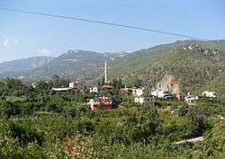
Üzümlü is a village in Erdemli district of Mersin Province, Turkey. At 36°51′N 34°20′E / 36.850°N 34.333°E it is situated in the valley of Müğlü creek in Toros Mountains. It is surrounded by pine forests and vineyards. Distance to Erdemli is 46 kilometres (29 mi) and to Mersin is 56 kilometres (35 mi). The population of Üzümlü was 254 as of 2012.[1] The village was founded 200 years ago by Yörüks (once nomadic Turkmens) from Alanya. Later another clan from Malatya also settled in Üzümlü. It was originally a neighbourhood of Şahna village. Then it was issued from Şahna and was declared a village. Farming is the major activity of the village. As the name of the village imply (Üzüm means "grape") the main crop of the village is grape. Citrus is also produced.[2]
References
- ↑ "Turkstat". Turkish Statistical Institute. Retrieved 2015. Check date values in:
|access-date=(help) - ↑ Erdemli chamber of agriculture (Turkish)